Akron
Airport details
| Country | United States of America |
| State | New York |
| Region | K6 |
| Airspace | Cleveland Ctr |
| Municipality | Town of Newstead |
| Elevation | 837ft (255m) |
| Timezone | GMT -5 |
| Coordinates | 43.02110, -78.48264 |
| Magnetic var | |
| Type | land |
| Available since | X-Plane v10.30 |
| ICAO code | 9G3 |
| IATA code | n/a |
| FAA code | n/a |
Communication
| Akron CTAF/UNICOM | 122.725 |
| Akron BUFFALO Approach/Departure | 126.150 |
Nearby Points of Interest:
United States Post Office
-Automobile Club of Buffalo
-Mount Pleasant
-J. Eshelman and Company Store
-Warren Hull House
-John Shelp Cobblestone House
-Oak Orchard Creek
-John Richardson House (Lancaster, New York)
-Zuidema-Idsardi House
-Herman B. VanPeyma House
-Lancaster District School No. 6
-Dr. John J. Nowak House
-Liebler-Rohl Gasoline Station
-DePew Lodge No. 823, Free and Accepted Masons
-Bruce-Briggs Brick Block
-Clark-Lester House
-Miller-Mackey House
-Lancaster Municipal Building
-John P. Sommers House
-William Taylor House
-Conkey House
-Garrison Cemetery
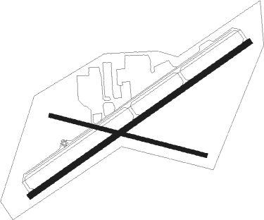
Runway info
Runway 7 / 25  | ||
| length | 994m (3261ft) | |
| bearing | 67° / 247° | |
| width | 23m (75ft) | |
| surface | asphalt | |
| blast zone | 79m (259ft) / 43m (141ft) | |
| Runway 11 / 29 | ||
| length | 595m (1952ft) | |
| bearing | 104° / 284° | |
| width | 15m (50ft) | |
| surface | grass | |
Nearby beacons
| code | identifier | dist | bearing | frequency |
|---|---|---|---|---|
| BU | KLUMP (BUFFALO) NDB | 7.4 | 263° | 231 |
| BUF | BUFFALO VOR/DME | 9 | 241° | 116.40 |
| IA | KATHI (NIAGRA FALLS) NDB | 16.4 | 284° | 329 |
| GB | PLAZZ (BUFFALO) NDB | 17.1 | 246° | 204 |
| IAG | NIAGARA FALLS TACAN | 21.6 | 281° | 111 |
| SN | ST CATHARINES NDB | 34.7 | 279° | 408 |
| GEE | GENESEO VOR/DME | 34.8 | 104° | 108.20 |
| ROC | ROCHESTER VOR/DME | 36 | 83° | 110 |
| DKK | DME | 47.2 | 236° | 116.20 |
| TZ | GIBRALTAR POINT NDB | 53 | 303° | 257 |
| YO | DME-ILS | 56.6 | 336° | 111.35 |
| OO | OSHAWA NDB | 57 | 335° | 391 |
| JHW | JAMESTOWN VOR/DME | 57.4 | 217° | 114.70 |
| ELZ | DME | 59.8 | 153° | 111.40 |
| KZ | BUTTONVILLE NDB | 66 | 317° | 248 |
Instrument approach procedures
| runway | airway (heading) | route (dist, bearing) |
|---|---|---|
| RW07 | OPDEQ (67°) | OPDEQ 6000ft OPDEQ (turn) 4000ft |
| RW07 | WOLUK (88°) | WOLUK OPDEQ (6mi, 141°) 4000ft |
| RW07 | ZUGIG (40°) | ZUGIG OPDEQ (6mi, 321°) 4000ft |
| RNAV | OPDEQ 4000ft RIZXU (6mi, 67°) 2500ft 9G3 (5mi, 67°) 870ft (4901mi, 119°) 1300ft OPDEQ (4910mi, 299°) 4000ft OPDEQ (turn) 4000ft | |
| RW25 | IGRUH (247°) | IGRUH 6000ft IGRUH (turn) 4000ft |
| RW25 | YATKU (220°) | YATKU IGRUH (6mi, 141°) 4000ft |
| RW25 | YEBSU (268°) | YEBSU IGRUH (6mi, 322°) 4000ft |
| RNAV | IGRUH 4000ft EKDOQ (6mi, 247°) 2500ft 9G3 (5mi, 247°) 880ft (4901mi, 119°) 1240ft IGRUH (4892mi, 299°) 4000ft IGRUH (turn) 4000ft |
Disclaimer
The information on this website is not for real aviation. Use this data with the X-Plane flight simulator only! Data taken with kind consent from X-Plane 12 source code and data files. Content is subject to change without notice.