Rif
Airport details
| Country | Iceland |
| State | Western Region |
| Region | BI |
| Airspace | Reykjavik Ctr |
| Municipality | Snæfellsbær |
| Elevation | 18ft (5m) |
| Timezone | GMT +0 |
| Coordinates | 64.91139, -23.82306 |
| Magnetic var | |
| Type | land |
| Available since | X-Plane v10.30 |
| ICAO code | BIRF |
| IATA code | OLI |
| FAA code | n/a |
Communication
| Rif AFIS | 118.100 |
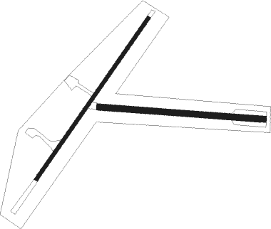
Runway info
Runway 05 / 23  | ||
| length | 981m (3219ft) | |
| bearing | 63° / 243° | |
| width | 20m (66ft) | |
| surface | asphalt | |
| displ threshold | 168m (551ft) / 0m (0ft) | |
| Runway 11 / 29 | ||
| length | 824m (2703ft) | |
| bearing | 94° / 274° | |
| width | 30m (98ft) | |
| surface | gravel | |
Nearby beacons
| code | identifier | dist | bearing | frequency |
|---|---|---|---|---|
| RF | RIF NDB | 0.1 | 65° | 330 |
| SB | SELARDALUR NDB | 52.8 | 349° | 310 |
Disclaimer
The information on this website is not for real aviation. Use this data with the X-Plane flight simulator only! Data taken with kind consent from X-Plane 12 source code and data files. Content is subject to change without notice.