Selfoss
Airport details
| Country | Iceland |
| State | Southern Region |
| Region | BI |
| Airspace | Reykjavik Ctr |
| Municipality | Sveitarfélagið Árborg |
| Elevation | 46ft (14m) |
| Timezone | GMT +0 |
| Coordinates | 63.92916, -21.03778 |
| Magnetic var | |
| Type | land |
| Available since | X-Plane v10.30 |
| ICAO code | BISF |
| IATA code | n/a |
| FAA code | n/a |
Communication
| Selfoss AFIS | 118.100 |
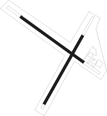
Runway info
Runway 05 / 23  | ||
| length | 796m (2612ft) | |
| bearing | 57° / 237° | |
| width | 30m (98ft) | |
| surface | gravel | |
| Runway 14 / 32 | ||
| length | 791m (2595ft) | |
| bearing | 110° / 290° | |
| width | 30m (98ft) | |
| surface | gravel | |
Nearby beacons
| code | identifier | dist | bearing | frequency |
|---|---|---|---|---|
| SE | SELFOSS NDB | 0 | 96° | 397 |
| EL | ELLIDAVATN NDB | 21.3 | 282° | 335 |
| RK | REYKJAVIK NDB | 29.2 | 283° | 355 |
| HL | HELGAFELL (VESTMANNAEYJAR) NDB | 36.3 | 124° | 345 |
| HL | (VESTMANNAEYJAR DME-ILS | 36.7 | 124° | 110.70 |
| VM | VESTMANNAEYJAR NDB | 37.5 | 125° | 375 |
| RH | REYKHOLT NDB | 44.6 | 341° | 325 |
Disclaimer
The information on this website is not for real aviation. Use this data with the X-Plane flight simulator only! Data taken with kind consent from X-Plane 12 source code and data files. Content is subject to change without notice.