Sandskeið - Sandskeid
Airport details
| Country | Iceland |
| State | Capital Region |
| Region | BI |
| Airspace | Reykjavik Ctr |
| Municipality | Kopavogur |
| Elevation | 600ft (183m) |
| Timezone | GMT +0 |
| Coordinates | 64.06084, -21.57472 |
| Magnetic var | |
| Type | land |
| Available since | X-Plane v10.40 |
| ICAO code | BISS |
| IATA code | n/a |
| FAA code | n/a |
Communication
| Sandskeid COM | 119.900 |
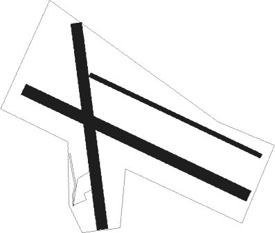
Runway info
Runway 01 / 19  | ||
| length | 850m (2789ft) | |
| bearing | 174° / 354° | |
| width | 46m (150ft) | |
| surface | grass | |
| Runway 15 / 33 | ||
| length | 799m (2621ft) | |
| bearing | 104° / 284° | |
| width | 18m (59ft) | |
| surface | asphalt | |
| Runway 15R / 33L | ||
| length | 1025m (3363ft) | |
| bearing | 104° / 284° | |
| width | 50m (164ft) | |
| surface | grass | |
Nearby beacons
| code | identifier | dist | bearing | frequency |
|---|---|---|---|---|
| EL | ELLIDAVATN NDB | 5.2 | 276° | 335 |
| RK | REYKJAVIK NDB | 13 | 281° | 355 |
| SE | SELFOSS NDB | 16.2 | 104° | 397 |
| RH | REYKHOLT NDB | 37 | 26° | 325 |
Disclaimer
The information on this website is not for real aviation. Use this data with the X-Plane flight simulator only! Data taken with kind consent from X-Plane 12 source code and data files. Content is subject to change without notice.