Urbana - Frasca Field
Airport details
| Country | United States of America |
| State | Illinois |
| Region | K5 |
| Airspace | Chicago Ctr |
| Municipality | Urbana |
| Elevation | 731ft (223m) |
| Timezone | GMT -6 |
| Coordinates | 40.14640, -88.19849 |
| Magnetic var | |
| Type | land |
| Available since | X-Plane v10.40 |
| ICAO code | C16 |
| IATA code | n/a |
| FAA code | n/a |
Communication
| Frasca Field CTAF/UNICOM | 122.800 |
| Frasca Field CHAMPAIGN Approach/Departure | 121.350 |
Nearby Points of Interest:
Building at 203–205 North Market Street
-Greek Revival Cottage
-Elm Street Court
-Nathan C. Ricker House
-Warm Air Research House
-Downtown Urbana Historic District
-Kenney Gym
-Illinois Traction Building
-Henry Ahrens House
-Natural History Building
-Harker Hall
-Orpheum Theatre
-Vriner's Confectionery
-Lincoln Building
-Building at 201 North Market Street
-Gamma Phi Beta Sorority House
-Channing-Murray Foundation
-Bailey–Rugg Building
-Busey-Evans Residence Halls
-Alpha Delta Pi Sorority House
-The Georgian
-United States Post Office
-Louise Freer Hall
-Smith Memorial Hall
-Delta Kappa Epsilon Fraternity House
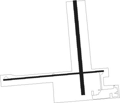
Runway info
Runway 9 / 27  | ||
| length | 1217m (3993ft) | |
| bearing | 90° / 270° | |
| width | 17m (55ft) | |
| surface | concrete | |
| Runway 18 / 36 | ||
| length | 1115m (3658ft) | |
| bearing | 179° / 359° | |
| width | 43m (140ft) | |
| surface | grass | |
| displ threshold | 0m (0ft) / 107m (351ft) | |
Nearby beacons
| code | identifier | dist | bearing | frequency |
|---|---|---|---|---|
| CMI | CHAMPAIGN VORTAC | 7.6 | 215° | 110 |
| CM | VEALS (CHAMPAIGN/URBANA) NDB | 10.8 | 175° | 407 |
| RBS | ROBERTS VOR/DME | 26.1 | 4° | 116.80 |
| DNV | DANVILLE VORTAC | 30.7 | 77° | 111 |
| DN | JULIP (DANVILLE) NDB | 31.8 | 78° | 332 |
| AXC | ADDERS VORTAC | 38.9 | 238° | 117.20 |
| BMI | BLOOMINGTON VOR/DME | 39.1 | 295° | 108.20 |
| LH | EGROW (BLOOMINGTON-NORMAL) NDB | 39.6 | 301° | 334 |
| MTO | DME | 40.3 | 187° | 109.40 |
| DE | ELWIN (DECATUR) NDB | 40.8 | 245° | 275 |
| PNT | PONTIAC VOR/DME | 47.3 | 322° | 109.60 |
| SYZ | SHELBYVILLE NDB | 53.4 | 221° | 365 |
| IK | LUKOW (KANKAKEE) NDB | 54 | 19° | 272 |
| IKK | DME | 57.9 | 21° | 111.60 |
| HU | YINNO (TERRE HAUTE) NDB | 58.6 | 133° | 245 |
| TTH | TERRE HAUTE VORTAC | 58.9 | 125° | 115.30 |
| DTG | DWIGHT NDB | 60.2 | 347° | 344 |
Disclaimer
The information on this website is not for real aviation. Use this data with the X-Plane flight simulator only! Data taken with kind consent from X-Plane 12 source code and data files. Content is subject to change without notice.