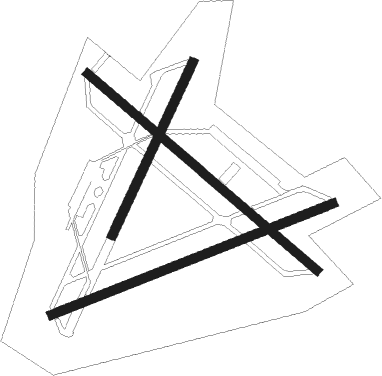
Debert
Airport details
| Country | Canada |
| State | Nova Scotia |
| Region | CY |
| Airspace | Moncton Ctr |
| Municipality | Debert |
| Elevation | 136ft (41m) |
| Timezone | GMT -4 |
| Coordinates | 45.41922, -63.46130 |
| Magnetic var | |
| Type | land |
| Available since | X-Plane v10.40 |
| ICAO code | CCQ3 |
| IATA code | n/a |
| FAA code | n/a |
Communication
| Debert CTAF/UNICOM | 123.000 |
| Debert HALIFAX TRML | 119.200 |
Runway info
Nearby beacons
| code | identifier | dist | bearing | frequency |
|---|---|---|---|---|
| ZNS | BLUENOSE (HALIFAX) NDB | 27.2 | 176° | 385 |
| YHZ | HALIFAX VOR/DME | 29.9 | 173° | 115.10 |
| ZHZ | SPLIT CROW (HALIFAX) NDB | 37.4 | 192° | 364 |
| UAW | SHEARWATER (HALIFAX) TACAN | 47.2 | 183° | 110.10 |
| YYG | CHARLOTTETOWN VOR/DME | 54.6 | 21° | 113.80 |
| 5B | SUMMERSIDE NDB | 61.2 | 337° | 254 |
Instrument approach procedures
| runway | airway (heading) | route (dist, bearing) |
|---|---|---|
| RW09 | DAVSO (57°) | DAVSO TIKIX (5mi, 336°) 1900ft |
| RW09 | XONGA (95°) | XONGA TIKIX (5mi, 156°) 1900ft |
| RNAV | TIKIX 1900ft IMAXA (6mi, 78°) 1800ft CCQ3 (6mi, 76°) 168ft XUMBU (7mi, 79°) 2600ft XUMBU (turn) | |
| RW27 | AVIXO (238°) | AVIXO HETHN (5mi, 157°) 2600ft |
| RW27 | OBVOV (277°) | OBVOV HETHN (5mi, 337°) 2600ft |
| RNAV | HETHN 2600ft IRBIK (6mi, 258°) 1800ft XUKTI (2mi, 258°) 1130ft CCQ3 (3mi, 260°) 170ft ULESI (7mi, 257°) 2600ft ULESI (turn) |
Disclaimer
The information on this website is not for real aviation. Use this data with the X-Plane flight simulator only! Data taken with kind consent from X-Plane 12 source code and data files. Content is subject to change without notice.

