Stanley
Airport details
| Country | Canada |
| State | Nova Scotia |
| Region | CY |
| Airspace | Moncton Ctr |
| Municipality | Stanley |
| Elevation | 95ft (29m) |
| Timezone | GMT -4 |
| Coordinates | 45.10056, -63.92056 |
| Magnetic var | |
| Type | land |
| Available since | X-Plane v10.40 |
| ICAO code | CCW4 |
| IATA code | n/a |
| FAA code | n/a |
Communication
| Stanley CTAF/UNICOM | 122.800 |
Nearby Points of Interest:
Hantsport Railway Station
-Uniacke Estate Museum Park
-Covenanter Church, Grand Pré, Nova Scotia
-Grand-Pré
-Shubenacadie residential school
-Elizabeth Bishop House
-St. George's Anglican Church
-Charles Macdonald Concrete House Museum
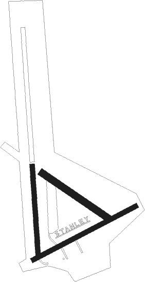
Runway info
Runway 02 / 20  | ||
| length | 549m (1801ft) | |
| bearing | 1° / 181° | |
| width | 30m (100ft) | |
| surface | grass | |
| Runway 09 / 27 | ||
| length | 732m (2402ft) | |
| bearing | 73° / 253° | |
| width | 30m (100ft) | |
| surface | gravel | |
| Runway 15 / 33 | ||
| length | 490m (1608ft) | |
| bearing | 120° / 300° | |
| width | 46m (150ft) | |
| surface | grass | |
Nearby beacons
| code | identifier | dist | bearing | frequency |
|---|---|---|---|---|
| ZNS | BLUENOSE (HALIFAX) NDB | 22.4 | 105° | 385 |
| ZHZ | SPLIT CROW (HALIFAX) NDB | 22.7 | 132° | 364 |
| YHZ | HALIFAX VOR/DME | 24.4 | 109° | 115.10 |
| UAW | SHEARWATER (HALIFAX) TACAN | 33.2 | 138° | 110.10 |
| GF | AYLESFORD (GREENWOOD) NDB | 38 | 265° | 341 |
| UZX | GREENWOOD TACAN | 42.9 | 263° | 117.60 |
| ZQM | RIVERVIEW (MONCTON) NDB | 66.9 | 317° | 304 |
Disclaimer
The information on this website is not for real aviation. Use this data with the X-Plane flight simulator only! Data taken with kind consent from X-Plane 12 source code and data files. Content is subject to change without notice.