Leader
Airport details
| Country | Canada |
| State | Saskatchewan |
| Region | CY |
| Airspace | Winnipeg Ctr |
| Municipality | Happyland No. 231 |
| Elevation | 2201ft (671m) |
| Timezone | GMT -6 |
| Coordinates | 50.87722, -109.50056 |
| Magnetic var | |
| Type | land |
| Available since | X-Plane v10.40 |
| ICAO code | CJD5 |
| IATA code | n/a |
| FAA code | n/a |
Communication
| Leader CTAF | 123.200 |
Nearby Points of Interest:
Empress Canadian Pacific Railway Station
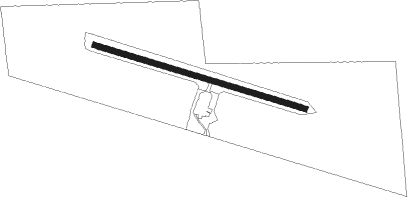
Runway info
| Runway 10 / 28 | ||
| length | 913m (2995ft) | |
| bearing | 104° / 284° | |
| width | 23m (75ft) | |
| surface | asphalt | |
Nearby beacons
| code | identifier | dist | bearing | frequency |
|---|---|---|---|---|
| YEA | DME | 18.7 | 276° | 115.90 |
| M3 | KINDERSLEY NDB | 40.3 | 27° | 402 |
| K5 | MAPLE CREEK NDB | 58.8 | 179° | 238 |
Disclaimer
The information on this website is not for real aviation. Use this data with the X-Plane flight simulator only! Data taken with kind consent from X-Plane 12 source code and data files. Content is subject to change without notice.