Santa Cruz - Bonny Doon Village
Airport details
| Country | United States of America |
| State | California |
| Region | |
| Airspace | Oakland Ctr |
| Municipality | Santa Cruz County |
| Elevation | 2020ft (616m) |
| Timezone | GMT -8 |
| Coordinates | 37.07215, -122.13103 |
| Magnetic var | |
| Type | land |
| Available since | X-Plane v10.40 |
| ICAO code | CL77 |
| IATA code | n/a |
| FAA code | CL77 |
Communication
Nearby Points of Interest:
Felton Presbyterian Church
-Cowell Lime Works
-Headquarters Administration Building
-Big Basin Redwoods State Park
-Glen Canyon Covered Bridge
-Branciforte Adobe
-Octagon Building
-Santa Cruz Looff Carousel and Roller Coaster
-Venetian Court
-McCullagh-Jones House
-Yung See San Fong House
-Saratoga
-New Almaden
-Le Petit Trianon
-Campbell High School
-Campbell Union Grammar School
-Capt. James A. Hamilton House
-Methodist Episcopal Church of Pescadero
-Galindo-Leigh House
-Castro Adobe
-Paul Shoup House
-Andrew J. Landrum House
-Hayes Mansion
-Casa De Tableta
-Leib Carriage House
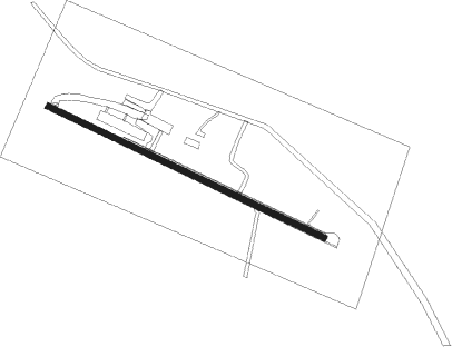
Runway info
| Runway 12 / 30 | ||
| length | 732m (2402ft) | |
| bearing | 115° / 295° | |
| width | 15m (50ft) | |
| surface | asphalt | |
Nearby beacons
| code | identifier | dist | bearing | frequency |
|---|---|---|---|---|
| SJC | SAN JOSE VOR/DME | 20.2 | 32° | 114.10 |
| OSI | WOODSIDE VOR/DME | 20.5 | 335° | 113.90 |
| NUQ | MOFFETT (MOUNTAIN VIEW) TACAN | 21.9 | 12° | 117.60 |
| MR | MUNSO (MONTEREY) NDB | 28.6 | 157° | 385 |
| SFO | SAN FRANCISCO VOR/DME | 34.8 | 336° | 115.80 |
| SNS | SALINAS VORTAC | 35.2 | 128° | 117.30 |
| OAK | OAKLAND VOR/DME | 39.5 | 352° | 116.80 |
| LV | REIGA (LIVERMORE) NDB | 42.9 | 36° | 374 |
| UAD | CHUALAR (SALINAS) NDB | 47 | 132° | 263 |
| SAU | SAUSALITO VOR/DME | 50.6 | 333° | 116.20 |
| BSR | BIG SUR VORTAC | 58.4 | 151° | 114 |
| CCR | CONCORD VOR/DME | 58.5 | 5° | 117 |
Disclaimer
The information on this website is not for real aviation. Use this data with the X-Plane flight simulator only! Data taken with kind consent from X-Plane 12 source code and data files. Content is subject to change without notice.