Emsdale
Airport details
| Country | Canada |
| State | Ontario |
| Region | CY |
| Airspace | Toronto Ctr |
| Municipality | Perry Township |
| Elevation | 1148ft (350m) |
| Timezone | GMT -5 |
| Coordinates | 45.54313, -79.34029 |
| Magnetic var | |
| Type | land |
| Available since | X-Plane v10.40 |
| ICAO code | CNA4 |
| IATA code | n/a |
| FAA code | n/a |
Communication
Nearby Points of Interest:
Huntsville station
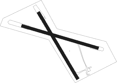
Runway info
Runway 17 / 35  | ||
| length | 738m (2421ft) | |
| bearing | 145° / 325° | |
| width | 30m (100ft) | |
| surface | grass | |
| displ threshold | 61m (200ft) / 0m (0ft) | |
| blast zone | 75m (246ft) / 0m (0ft) | |
| Runway 12 / 30 | ||
| length | 764m (2507ft) | |
| bearing | 105° / 285° | |
| width | 30m (98ft) | |
| surface | grass | |
| blast zone | 117m (384ft) / 0m (0ft) | |
Nearby beacons
| code | identifier | dist | bearing | frequency |
|---|---|---|---|---|
| YYB | NORTH BAY VOR/DME | 49.4 | 353° | 115.40 |
| YEE | MIDLAND VOR/DME | 60.8 | 205° | 112.80 |
Disclaimer
The information on this website is not for real aviation. Use this data with the X-Plane flight simulator only! Data taken with kind consent from X-Plane 12 source code and data files. Content is subject to change without notice.