Brockville - Brockville 1000 Island Rgl
Airport details
| Country | Canada |
| State | Ontario |
| Region | CY |
| Airspace | Montreal Ctr |
| Municipality | Elizabethtown-Kitley |
| Elevation | 402ft (123m) |
| Timezone | GMT -5 |
| Coordinates | 44.63942, -75.75018 |
| Magnetic var | |
| Type | land |
| Available since | X-Plane v10.40 |
| ICAO code | CNL3 |
| IATA code | XBR |
| FAA code | n/a |
Communication
| Brockville 1000 Island Rgl Brockville UNICOM | 123.000 |
Nearby Points of Interest:
Wright's Stone Store
-Land Office
-Jacob Ford House
-Paschal Miller House
-McConnell's Windmill
-United Methodist Church (Morristown, New York)
-Morristown Schoolhouse
-Fort de La Présentation
-Robert C. McEwen United States Custom House
-George C. Boldt Yacht House
-Cornwall Brothers' Store
-Holland Library
-Dr. Abner Benton House
-United States Post Office
-Thousand Island Park Historic District
-Rock Island Light
-Methodist-Protestant Church at Fisher's Landing
-Methodist Episcopal Church (Orleans, New York)
-Village Park Historic District
-Herring-Cole Hall, St. Lawrence University
-St. Lawrence University-Old Campus Historic District
-Richardson Hall, St. Lawrence University
-Buck's Bridge Community Church
-Waddington Historic District
-Sunday Rock
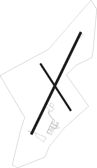
Runway info
Runway 04 / 22  | ||
| length | 1371m (4498ft) | |
| bearing | 39° / 219° | |
| width | 28m (93ft) | |
| surface | asphalt | |
| Runway 16 / 34 | ||
| length | 671m (2201ft) | |
| bearing | 143° / 323° | |
| width | 24m (80ft) | |
| surface | grass | |
Nearby beacons
| code | identifier | dist | bearing | frequency |
|---|---|---|---|---|
| OG | OGIVE (OGDENSBURG) NDB | 17.3 | 81° | 358 |
| PTD | POTSDAM NDB | 37.3 | 84° | 400 |
| MS | MISSE (MASSENA) NDB | 37.8 | 76° | 278 |
| YGK | KINGSTON NDB | 42 | 248° | 263 |
| ART | WATERTOWN VORTAC | 43.4 | 205° | 109.80 |
| OW | OTTAWA NDB | 44 | 15° | 236 |
| YOW | OTTAWA VOR/DME | 48.5 | 350° | 114.60 |
Instrument approach procedures
| runway | airway (heading) | route (dist, bearing) |
|---|---|---|
| RW04 | GABLU (64°) | GABLU IRLIS (5mi, 113°) 1700ft |
| RNAV | IRLIS 1700ft KELSU (6mi, 39°) 1700ft CNL3 (4mi, 39°) 445ft OMPEL (6mi, 40°) 2100ft OMPEL (turn) | |
| RW22 | SIDVO (245°) | SIDVO EPRIL (5mi, 293°) 1700ft |
| RW22 | VIKLA (186°) | VIKLA EPRIL (5mi, 113°) 1700ft |
| RNAV | EPRIL 1700ft KESBU (6mi, 220°) 1700ft CNL3 (4mi, 220°) 445ft SEKAK (3mi, 219°) XOXAV (5mi, 239°) 2100ft XOXAV (turn) |
Disclaimer
The information on this website is not for real aviation. Use this data with the X-Plane flight simulator only! Data taken with kind consent from X-Plane 12 source code and data files. Content is subject to change without notice.