Welland - Welland Niagara Central
Airport details
| Country | Canada |
| State | Ontario |
| Region | CY |
| Airspace | Toronto Ctr |
| Municipality | Pelham |
| Elevation | 583ft (178m) |
| Timezone | GMT -5 |
| Coordinates | 42.98012, -79.32465 |
| Magnetic var | |
| Type | land |
| Available since | X-Plane v10.40 |
| ICAO code | CNQ3 |
| IATA code | n/a |
| FAA code | n/a |
Communication
| Welland Niagara Central CTAF/UNICOM | 123.500 |
| Welland Niagara Central BUFFALO Approach | 126.500 |
| Welland Niagara Central TORONTO TRML | 133.400 |
Nearby Points of Interest:
Comfort Maple
-British Methodist Episcopal Church, Salem Chapel
-Mohawk Island Lighthouse
-First Presbyterian Manse
-Whitney Mansion (Niagara Falls, New York)
-James G. Marshall House
-Jefferson Apartment Building
-Holley-Rankine House
-Hazard H. Sheldon House
-United States Post Office
-Park Place Historic District
-Niagara Falls City Hall
-Niagara Falls Armory
-Chilton Avenue-Orchard Parkway Historic District
-Holy Trinity Roman Catholic Church Complex (Niagara Falls, New York)
-Niagara Falls Public Library
-Niagara Falls Station and Customhouse Interpretive Center
-Former Niagara Falls High School
-Spaulding-Sidway Boathouse
-Willowbank Estate
-Johann Williams Farm
-Town of Niagara District School No. 2
-Eberz House
-House at 218 Dearborn Street
-Dayton House
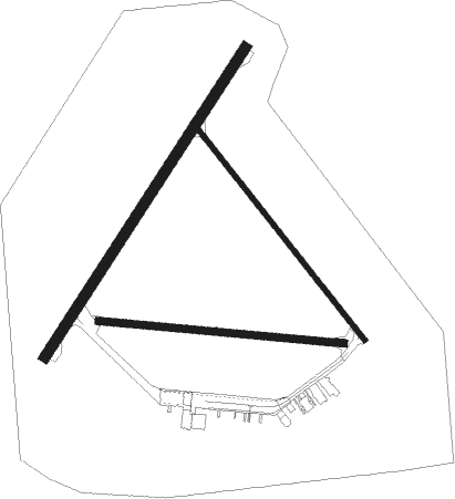
Runway info
Runway 16 / 34  | ||
| length | 805m (2641ft) | |
| bearing | 138° / 318° | |
| width | 15m (50ft) | |
| surface | asphalt | |
| Runway 05 / 23 | ||
| length | 1069m (3507ft) | |
| bearing | 46° / 226° | |
| width | 30m (100ft) | |
| surface | asphalt | |
| Runway 11 / 29 | ||
| length | 714m (2343ft) | |
| bearing | 97° / 277° | |
| width | 21m (70ft) | |
| surface | grass | |
Nearby beacons
| code | identifier | dist | bearing | frequency |
|---|---|---|---|---|
| SN | ST CATHARINES NDB | 10.4 | 23° | 408 |
| IAG | NIAGARA FALLS TACAN | 17.8 | 70° | 111 |
| IA | KATHI (NIAGRA FALLS) NDB | 22.7 | 75° | 329 |
| ZHM | BINBROOK (HAMILTON) NDB | 22.7 | 289° | 266 |
| GB | PLAZZ (BUFFALO) NDB | 23.2 | 102° | 204 |
| DKK | DME | 29.4 | 174° | 116.20 |
| BU | KLUMP (BUFFALO) NDB | 29.6 | 88° | 231 |
| BUF | BUFFALO VOR/DME | 29.9 | 94° | 116.40 |
| HM | HAMILTON NDB | 31.1 | 282° | 221 |
| ZHA | ANCASTER (HAMILTON) NDB | 33.4 | 287° | 397 |
| TZ | GIBRALTAR POINT NDB | 38 | 354° | 257 |
| ZYZ | QUEENSWAY (TORONTO) NDB | 39.6 | 341° | 368 |
| YYZ | TORONTO VOR/DME | 42.8 | 336° | 112.15 |
| YTP | PEARSON (TORONTO) VOR/DME | 44.1 | 334° | 116.55 |
| JHW | JAMESTOWN VOR/DME | 48.3 | 166° | 114.70 |
| ZTO | WOODHILL (TORONTO) NDB | 48.4 | 333° | 403 |
| ZKF | WELLINGTON (KITCHENER) NDB | 52.1 | 298° | 335 |
| KZ | BUTTONVILLE NDB | 57.2 | 360° | 248 |
| OO | OSHAWA NDB | 59.4 | 24° | 391 |
| YO | DME-ILS | 59.5 | 25° | 111.35 |
| ERI | ERIE VORTAC | 71.9 | 225° | 109.40 |
Instrument approach procedures
| runway | airway (heading) | route (dist, bearing) |
|---|---|---|
| RW05 | TAKDO (27°) | TAKDO ROGDU (5mi, 308°) 2800ft |
| RW05 | VIGPO (76°) | VIGPO ROGDU (5mi, 128°) 2800ft |
| RNAV | ROGDU 2800ft METMI (5mi, 55°) 2300ft NADGU (5mi, 55°) 788ft (4938mi, 118°) 1600ft VIGPO (4948mi, 298°) 2800ft VIGPO (turn) |
Disclaimer
The information on this website is not for real aviation. Use this data with the X-Plane flight simulator only! Data taken with kind consent from X-Plane 12 source code and data files. Content is subject to change without notice.