Tyendinaga - Mohawk
Airport details
| Country | Canada |
| State | Ontario |
| Region | CY |
| Airspace | Toronto Ctr |
| Municipality | Hastings County |
| Elevation | 257ft (78m) |
| Timezone | GMT -5 |
| Coordinates | 44.18472, -77.10778 |
| Magnetic var | |
| Type | land |
| Available since | X-Plane v10.40 |
| ICAO code | CPU6 |
| IATA code | n/a |
| FAA code | n/a |
Communication
| Mohawk CTAF/UNICOM | 123.500 |
Nearby Points of Interest:
Glanmore House
-Belleville City Hall
-Tara Hall
-Carrying Place
-Collins Bay Institution
-Prison for Women
-Roselawn
-Kingston General Hospital
-Frontenac County Court House
-Kingston City Hall
-Shoal Tower
-Fort Frontenac
-Kingston Royal Naval Dockyard
-Currie Hall
-HMCS Stone Frigate
-Cathcart Tower
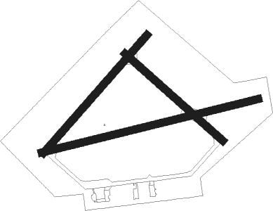
Runway info
Runway 06 / 24  | ||
| length | 913m (2995ft) | |
| bearing | 55° / 235° | |
| width | 46m (150ft) | |
| surface | asphalt | |
| Runway 09 / 27 | ||
| length | 1299m (4262ft) | |
| bearing | 83° / 263° | |
| width | 46m (150ft) | |
| surface | asphalt | |
| displ threshold | 119m (390ft) / 0m (0ft) | |
| Runway 15 / 33 | ||
| length | 760m (2493ft) | |
| bearing | 127° / 307° | |
| width | 46m (150ft) | |
| surface | asphalt | |
| displ threshold | 1m (3ft) / 0m (0ft) | |
| blast zone | 121m (397ft) / 0m (0ft) | |
Nearby beacons
| code | identifier | dist | bearing | frequency |
|---|---|---|---|---|
| YTR | TRENTON NDB | 12.7 | 272° | 215 |
| UTR | TRENTON TACAN | 18.5 | 261° | 109.70 |
| YGK | KINGSTON NDB | 22.6 | 77° | 263 |
| ZZR | SEVERN (TRENTON) NDB | 23.7 | 256° | 317 |
| YCF | DME | 27.1 | 284° | 113.50 |
| VIE | COEHILL VOR/DME | 44 | 301° | 115.10 |
| FZ | FALLN (FULTON) NDB | 64.1 | 138° | 220 |
Disclaimer
The information on this website is not for real aviation. Use this data with the X-Plane flight simulator only! Data taken with kind consent from X-Plane 12 source code and data files. Content is subject to change without notice.