Dauphin - Dauphin Barker
Airport details
| Country | Canada |
| State | Manitoba |
| Region | CY |
| Airspace | Winnipeg Ctr |
| Municipality | Rural Municipality of Dauphin |
| Elevation | 999ft (304m) |
| Timezone | GMT -6 |
| Coordinates | 51.10152, -100.05326 |
| Magnetic var | |
| Type | land |
| Available since | X-Plane v10.40 |
| ICAO code | CYDN |
| IATA code | YDN |
| FAA code | n/a |
Communication
| Dauphin Barker AWOS | 128.600 |
| Dauphin Barker MF WINNIPEG RDO | 122.300 |
Nearby Points of Interest:
Dauphin Town Hall
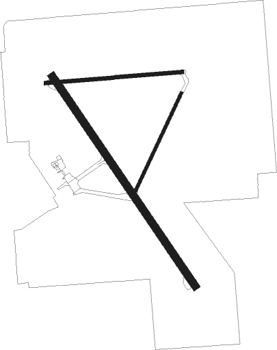
Runway info
Runway 14 / 32  | ||
| length | 1526m (5007ft) | |
| bearing | 138° / 318° | |
| width | 46m (150ft) | |
| surface | asphalt | |
| Runway 08 / 26 | ||
| length | 824m (2703ft) | |
| bearing | 90° / 270° | |
| width | 23m (75ft) | |
| surface | asphalt | |
| Runway 02 / 20 | ||
| length | 644m (2113ft) | |
| bearing | 42° / 222° | |
| width | 18m (60ft) | |
| surface | gravel | |
Nearby beacons
| code | identifier | dist | bearing | frequency |
|---|---|---|---|---|
| YDN | DAUPHIN VOR/DME | 0.2 | 15° | 116.10 |
| DN | DAUPHIN NDB | 0.3 | 242° | 224 |
Instrument approach procedures
| runway | airway (heading) | route (dist, bearing) |
|---|---|---|
| RW14 | SIDGI (113°) | SIDGI OMPOX (5mi, 70°) 2500ft |
| RW14 | TUKAS (175°) | TUKAS OMPOX (5mi, 250°) 2500ft |
| RNAV | OMPOX 2500ft URPEL (5mi, 137°) 2500ft CYDN (5mi, 138°) 1039ft DURUB (5mi, 138°) 3700ft DURUB (turn) | |
| RW32 | KEGMI (296°) | KEGMI MIDBO (5mi, 250°) 3600ft |
| RW32 | ROLRA (348°) | ROLRA MIDBO (5mi, 70°) 3600ft |
| RNAV | MIDBO 3600ft TIGOL (5mi, 318°) 3280ft PEPNU (1mi, 318°) 2900ft MAREB (4mi, 318°) 1690ft CYDN (2mi, 318°) 1049ft AVSUG (5mi, 318°) 3700ft AVSUG (turn) |
Disclaimer
The information on this website is not for real aviation. Use this data with the X-Plane flight simulator only! Data taken with kind consent from X-Plane 12 source code and data files. Content is subject to change without notice.