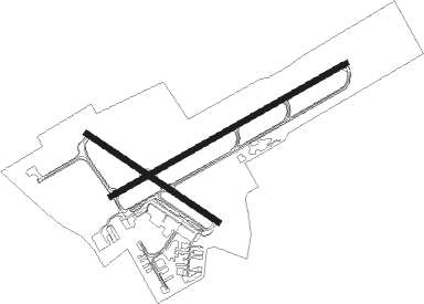
Breslau - Waterloo Intl
Airport details
| Country | Canada |
| State | Ontario |
| Region | CY |
| Airspace | Toronto Ctr |
| Municipality | Woolwich |
| Elevation | 1054ft (321m) |
| Timezone | GMT -5 |
| Coordinates | 43.46077, -80.37872 |
| Magnetic var | |
| Type | land |
| Available since | X-Plane v10.40 |
| ICAO code | CYKF |
| IATA code | YKF |
| FAA code | YKF |
Communication
| Waterloo Intl ATIS | 125.100 |
| Waterloo Intl Ground Control | 121.800 |
| Waterloo Intl Tower | 126.000 |
| Waterloo Intl TORONTO TRML | 128.275 |
| Waterloo Intl DepartureARTURE | 128.275 |
Approach frequencies
| ILS-cat-I | RW26 | 110.7 | 18.00mi |
| 3° GS | RW26 | 110.7 | 18.00mi |
Nearby beacons
| code | identifier | dist | bearing | frequency |
|---|---|---|---|---|
| WT | (KITCHENER) DME | 0.1 | 197° | 115 |
| ZKF | WELLINGTON (KITCHENER) NDB | 4.4 | 71° | 335 |
| ZHA | ANCASTER (HAMILTON) NDB | 22 | 127° | 397 |
| FD | BRANTFORD NDB | 23.3 | 186° | 207 |
| HM | HAMILTON NDB | 26 | 132° | 221 |
| ZHM | BINBROOK (HAMILTON) NDB | 31.8 | 118° | 266 |
| YTP | PEARSON (TORONTO) VOR/DME | 33.5 | 74° | 116.55 |
| ZTO | WOODHILL (TORONTO) NDB | 33.7 | 68° | 403 |
| YYZ | TORONTO VOR/DME | 34.6 | 75° | 112.15 |
| ZYZ | QUEENSWAY (TORONTO) NDB | 37.4 | 79° | 368 |
| YXU | LONDON VOR/DME | 42.1 | 241° | 117.20 |
| YMS | MANS (MANSFIELD) VOR/DME | 42.2 | 19° | 114.50 |
| TZ | GIBRALTAR POINT NDB | 44.1 | 81° | 257 |
Departure and arrival routes
| Transition altitude | 18000ft |
| Transition level | 18000ft |
| SID end points | distance | outbound heading | |
|---|---|---|---|
| RW08 | |||
| CYKF3 | 44mi | 80° | |
| RW14 | |||
| CYKF3 | 44mi | 80° | |
| RW26 | |||
| CYKF3 | 44mi | 80° | |
| RW32 | |||
| CYKF3 | 44mi | 80° | |
Instrument approach procedures
| runway | airway (heading) | route (dist, bearing) |
|---|---|---|
| RW08-Y | CANIG (20°) | CANIG 4000ft XUDBO (3mi, 301°) 3500ft AXIBA (3mi, 340°) 2700ft IKMID (2mi, 52°) 2100ft |
| RW08-Y | DUPUR (72°) | DUPUR 3000ft IKMID (5mi, 71°) 2100ft |
| RW08-Y | MUPUX (98°) | MUPUX 4000ft OLELA (3mi, 129°) 3000ft IKMID (3mi, 98°) 2100ft |
| RW08-Y | SEPKA (113°) | SEPKA 4000ft NADEB (3mi, 194°) 3600ft OLELA (2mi, 159°) 3000ft IKMID (3mi, 98°) 2100ft |
| RW08-Y | VIXIG (50°) | VIXIG 4000ft AXIBA (4mi, 27°) 2700ft IKMID (2mi, 52°) 2100ft |
| RNAV | IKMID 2100ft CYKF (4mi, 72°) 1073ft LIBIL (10mi, 71°) 4000ft LIBIL (turn) | |
| RW08-Z | LESAV (45°) | LESAV 3000ft DUPUR (5mi, 327°) 3000ft |
| RW08-Z | UBVOT (93°) | UBVOT 3000ft DUPUR (5mi, 147°) 3000ft |
| RNAV | DUPUR 3000ft IKMID (5mi, 71°) 2100ft XOXAT (1mi, 71°) 1630ft CYKF (2mi, 72°) 1073ft LIBIL (10mi, 71°) 4000ft LIBIL (turn) | |
| RW14 | ADRUN (95°) | ADRUN 3000ft KIXAK (5mi, 47°) 3000ft |
| RW14 | ROGPA (150°) | ROGPA 3000ft KIXAK (5mi, 227°) 3000ft |
| RNAV | KIXAK 3000ft SUTNO (5mi, 120°) 2100ft CYKF (4mi, 116°) 1077ft NUDIB (8mi, 122°) 4000ft NUDIB (turn) | |
| RW26-Y | ALKAP (169°) | ALKAP 4000ft XUDLO (3mi, 71°) 4000ft PUXAG (4mi, 111°) 3100ft DAXUN (3mi, 216°) 2200ft |
| RW26-Y | KETPU (309°) | KETPU 4000ft SUGUB (3mi, 71°) 4000ft XOSIG (3mi, 36°) 3400ft DAXUN (4mi, 291°) 2200ft |
| RW26-Y | LIBIL (251°) | LIBIL 3000ft DAXUN (6mi, 251°) 2200ft |
| RW26-Y | OVUSA (220°) | OVUSA 4000ft PUXAG (3mi, 166°) 3100ft DAXUN (3mi, 216°) 2200ft |
| RW26-Y | TAVRI (286°) | TAVRI 4000ft XOSIG (3mi, 346°) 3400ft DAXUN (4mi, 291°) 2200ft |
| RNAV | DAXUN 2200ft CYKF (4mi, 251°) 1100ft DUPUR (9mi, 252°) 4000ft DUPUR (turn) | |
| RW26-Z | MAPEM (228°) | MAPEM 3000ft LIBIL (5mi, 148°) 3000ft |
| RW26-Z | OMTED (271°) | OMTED 3000ft LIBIL (5mi, 328°) 3000ft |
| RNAV | LIBIL 3000ft DAXUN (6mi, 251°) 2200ft KIVIN (2mi, 251°) 1610ft CYKF (2mi, 250°) 1100ft DUPUR (9mi, 252°) 4000ft DUPUR (turn) | |
| RW32 | PIDGA (276°) | PIDGA 3000ft NUDIB (5mi, 228°) 3000ft |
| RW32 | SUXIB (335°) | SUXIB 3000ft NUDIB (5mi, 47°) 3000ft |
| RNAV | NUDIB 3000ft NOXEX (5mi, 300°) 2100ft XOVRO (2mi, 300°) 1530ft CYKF (2mi, 309°) 1071ft KIXAK (9mi, 298°) 4000ft KIXAK (turn) |
Disclaimer
The information on this website is not for real aviation. Use this data with the X-Plane flight simulator only! Data taken with kind consent from X-Plane 12 source code and data files. Content is subject to change without notice.

