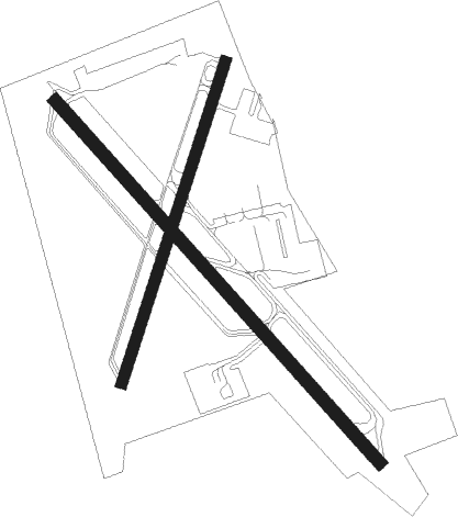
Toronto - Buttonville Muni
Airport details
| Country | Canada |
| State | Ontario |
| Region | CY |
| Airspace | Toronto Ctr |
| Municipality | Markham |
| Elevation | 647ft (197m) |
| Timezone | GMT -5 |
| Coordinates | 43.86086, -79.36873 |
| Magnetic var | |
| Type | land |
| Available since | X-Plane v10.40 |
| ICAO code | CYKZ |
| IATA code | YKZ |
| FAA code | n/a |
Communication
| BUTTONVILLE MUNI ATIS | 127.100 |
| BUTTONVILLE MUNI Ground Control | 121.800 |
| BUTTONVILLE MUNI Tower | 124.800 |
| BUTTONVILLE MUNI Tower | 119.900 |
| BUTTONVILLE MUNI TRML Approach | 133.400 |
| BUTTONVILLE MUNI TRML Departure | 133.400 |
Approach frequencies
| LOC | RW15 | 111.1 | 18.00mi |
Nearby beacons
| code | identifier | dist | bearing | frequency |
|---|---|---|---|---|
| KZ | BUTTONVILLE NDB | 4.6 | 29° | 248 |
| TZ | GIBRALTAR POINT NDB | 14.9 | 184° | 257 |
| ZTO | WOODHILL (TORONTO) NDB | 16.2 | 250° | 403 |
| ZYZ | QUEENSWAY (TORONTO) NDB | 16.4 | 217° | 368 |
| YYZ | TORONTO VOR/DME | 16.6 | 232° | 112.15 |
| YTP | PEARSON (TORONTO) VOR/DME | 17.1 | 237° | 116.55 |
| OO | OSHAWA NDB | 20.6 | 83° | 391 |
| YO | DME-ILS | 21.1 | 83° | 111.35 |
| YSO | DME | 24.2 | 28° | 117.35 |
| YMS | MANS (MANSFIELD) VOR/DME | 37.6 | 290° | 114.50 |
| SN | ST CATHARINES NDB | 43.1 | 171° | 408 |
| YPQ | PETERBOROUGH NDB | 44.4 | 69° | 379 |
| ZKF | WELLINGTON (KITCHENER) NDB | 45.5 | 248° | 335 |
| ZHM | BINBROOK (HAMILTON) NDB | 46.8 | 211° | 266 |
| YEE | MIDLAND VOR/DME | 46.9 | 330° | 112.80 |
| IAG | NIAGARA FALLS TACAN | 48.3 | 151° | 111 |
| ZHA | ANCASTER (HAMILTON) NDB | 49.1 | 225° | 397 |
| IA | KATHI (NIAGRA FALLS) NDB | 50.7 | 145° | 329 |
| HM | HAMILTON NDB | 52.4 | 221° | 221 |
| BU | KLUMP (BUFFALO) NDB | 60.4 | 140° | 231 |
| GB | PLAZZ (BUFFALO) NDB | 63.9 | 151° | 204 |
| BUF | BUFFALO VOR/DME | 64.2 | 142° | 116.40 |
Departure and arrival routes
| Transition altitude | 18000ft |
| Transition level | 18000ft |
| SID end points | distance | outbound heading | |
|---|---|---|---|
| RW03 | |||
| KEPTA3 | 62mi | 146° | |
| RIGUS4 | 187mi | 155° | |
| CYKZ3 | 14mi | 185° | |
| BETES3 | 168mi | 203° | |
| ANCOL5 | 133mi | 241° | |
| GOPUP3 | 243mi | 266° | |
| RW15 | |||
| KEPTA3 | 62mi | 146° | |
| RIGUS4 | 187mi | 155° | |
| CYKZ3 | 14mi | 185° | |
| BETES3 | 168mi | 203° | |
| ANCOL5 | 133mi | 241° | |
| GOPUP3 | 243mi | 266° | |
| RW21 | |||
| KEPTA3 | 62mi | 146° | |
| RIGUS4 | 187mi | 155° | |
| CYKZ3 | 14mi | 185° | |
| BETES3 | 168mi | 203° | |
| ANCOL5 | 133mi | 241° | |
| GOPUP3 | 243mi | 266° | |
| RW33 | |||
| KEPTA3 | 62mi | 146° | |
| RIGUS4 | 187mi | 155° | |
| CYKZ3 | 14mi | 185° | |
| BETES3 | 168mi | 203° | |
| ANCOL5 | 133mi | 241° | |
| GOPUP3 | 243mi | 266° | |
Instrument approach procedures
| runway | airway (heading) | route (dist, bearing) |
|---|---|---|
| RW03 | UDGIG (299°) | UDGIG SEDOR (5mi, 241°) 2100ft |
| RNAV | SEDOR 2100ft TIGOM (6mi, 313°) 2000ft VILSU (3mi, 349°) 888ft UDGIG (10mi, 114°) 2400ft UDGIG (turn) | |
| RW15 | OTOMU (163°) | OTOMU ROMDO (5mi, 241°) 2500ft |
| RNAV | ROMDO 2500ft SIMTU (6mi, 133°) 2300ft XUBUK (2mi, 133°) 1360ft CYKZ (2mi, 133°) 695ft TUBUX (5mi, 133°) 2500ft TUBUX (turn) | |
| RW21 | ETKOB (175°) | ETKOB ITLIM (5mi, 106°) 2500ft |
| RW21 | NOXUP (237°) | NOXUP ITLIM (5mi, 287°) 2500ft |
| RNAV | ITLIM 2500ft OMLUP (6mi, 210°) 2000ft CYKZ (4mi, 208°) 700ft NOXUP (11mi, 57°) 2600ft NOXUP (turn) | |
| RW33 | MEVTO (313°) | MEVTO VIGSA (5mi, 314°) 2800ft |
| RW33 | PESGI (290°) | PESGI VIGSA (5mi, 241°) 2800ft |
| RNAV | VIGSA 2800ft LOBNI (6mi, 313°) 2300ft SINRU (3mi, 313°) 1100ft CYKZ (2mi, 314°) 692ft METLU (10mi, 313°) 3000ft METLU (turn) |
Disclaimer
The information on this website is not for real aviation. Use this data with the X-Plane flight simulator only! Data taken with kind consent from X-Plane 12 source code and data files. Content is subject to change without notice.

