Chapleau
Airport details
| Country | Canada |
| State | Ontario |
| Region | CY |
| Airspace | Toronto Ctr |
| Municipality | Unorganized North Sudbury |
| Elevation | 1470ft (448m) |
| Timezone | GMT -5 |
| Coordinates | 47.82018, -83.34689 |
| Magnetic var | |
| Type | land |
| Available since | X-Plane v10.40 |
| ICAO code | CYLD |
| IATA code | YLD |
| FAA code | n/a |
Communication
| Chapleau CTAF/UNICOM | 122.800 |
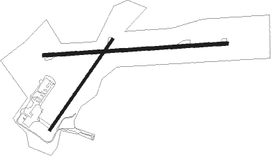
Runway info
Runway 10 / 28  | ||
| length | 1527m (5010ft) | |
| bearing | 91° / 271° | |
| width | 30m (100ft) | |
| surface | asphalt | |
| Runway 05 / 23 | ||
| length | 917m (3009ft) | |
| bearing | 51° / 231° | |
| width | 23m (75ft) | |
| surface | asphalt | |
Nearby beacons
| code | identifier | dist | bearing | frequency |
|---|---|---|---|---|
| YLD | CHAPLEAU NDB | 4.6 | 225° | 335 |
Instrument approach procedures
| runway | airway (heading) | route (dist, bearing) |
|---|---|---|
| RW10 | AGLIR (109°) | AGLIR BEMEG (5mi, 181°) 3200ft |
| RW10 | DUXOV (73°) | DUXOV BEMEG (5mi, 1°) 3200ft |
| RNAV | BEMEG 3200ft GOSAB (6mi, 91°) 2800ft CYLD (4mi, 92°) 1520ft IKNIV (5mi, 89°) 3200ft IKNIV (turn) | |
| RW28 | LESUB (288°) | LESUB ILUBI (5mi, 2°) 3000ft |
| RW28 | MERPA (253°) | MERPA ILUBI (5mi, 182°) 3000ft |
| RNAV | ILUBI 3000ft EMASO (6mi, 271°) 2800ft CYLD (5mi, 269°) 1472ft NAMGA (5mi, 272°) 3200ft NAMGA (turn) |
Disclaimer
The information on this website is not for real aviation. Use this data with the X-Plane flight simulator only! Data taken with kind consent from X-Plane 12 source code and data files. Content is subject to change without notice.