Pitt Meadows
Airport details
| Country | Canada |
| State | British Columbia |
| Region | CY |
| Airspace | Vancouver Ctr |
| Municipality | Pitt Meadows |
| Elevation | 11ft (3m) |
| Timezone | GMT -8 |
| Coordinates | 49.22044, -122.71797 |
| Magnetic var | |
| Type | land |
| Available since | X-Plane v10.40 |
| ICAO code | CYPK |
| IATA code | n/a |
| FAA code | n/a |
Communication
| Pitt Meadows ATIS 125.0 | 125.000 |
| Pitt Meadows Ground Control 123.8 | 123.800 |
| Pitt Meadows Tower 126.3 | 126.300 |
| Pitt Meadows Departure 132.3 | 132.300 |
Nearby Points of Interest:
Fort Langley National Historic Site
-MV Plover
-Carnegie Community Centre
-Pantages Theatre
-Sam Kee Building
-Sun Tower
-Victory Square, Vancouver
-Beatty Street Drill Hall
-Dominion Building
-Marine Building
-Great Marpole Midden
-Seaforth Armoury
-St. Roch
-Bessborough Armoury
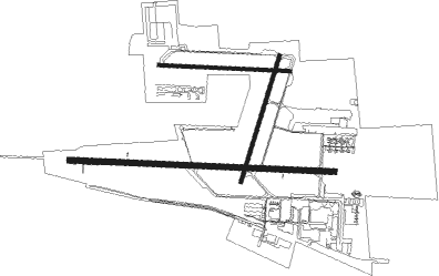
Runway info
Runway 08R / 26L  | ||
| length | 1522m (4993ft) | |
| bearing | 95° / 275° | |
| width | 30m (100ft) | |
| surface | asphalt | |
| displ threshold | 61m (200ft) / 52m (171ft) | |
| Runway 18 / 36 | ||
| length | 758m (2487ft) | |
| bearing | 211° / 31° | |
| width | 23m (75ft) | |
| surface | asphalt | |
| Runway 08L / 26R | ||
| length | 753m (2470ft) | |
| bearing | 95° / 275° | |
| width | 23m (75ft) | |
| surface | asphalt | |
| Runway 11 / 29 | ||
| length | 1223m (4012ft) | |
| bearing | 107° / 287° | |
| width | 49m (162ft) | |
Nearby beacons
| code | identifier | dist | bearing | frequency |
|---|---|---|---|---|
| YPK | PITT MEADOWS VOR | 0.2 | 146° | 112.40 |
| WC | WHITE ROCK NDB | 13.1 | 188° | 332 |
| VR | VANCOUVER NDB | 13.6 | 262° | 266 |
| XX | ABBOTSFORD NDB | 15.2 | 132° | 344 |
| HUH | WHATCOM VORTAC | 17.4 | 153° | 113 |
| YVR | VANCOUVER VOR/DME | 18.9 | 252° | 115.90 |
| AP | ACTIVE PASS NDB | 30.6 | 239° | 378 |
| YYJ | VICTORIA VOR/DME | 42.3 | 237° | 113.70 |
| YJ | VICTORIA NDB | 43.8 | 230° | 200 |
| FHR | FRIDAY HARBOR NDB | 44.2 | 203° | 284 |
| MB | MILL BAY (VICTORIA) NDB | 46.1 | 236° | 293 |
| BVS | SKAGIT/BAY VIEW (BURLINGTON) NDB | 46.6 | 158° | 240 |
| NUW | WHIDBEY ISLAND (OAK HARBO TACAN | 52 | 176° | 113.80 |
| CVV | PENN COVE VOR/DME | 58.6 | 180° | 117.20 |
Departure and arrival routes
| Transition altitude | 18000ft |
| Transition level | 18000ft |
| SID end points | distance | outbound heading | |
|---|---|---|---|
| RW08R | |||
| CYPK2 | 13mi | 188° | |
| RW26L | |||
| CYPK2 | 13mi | 188° | |
Instrument approach procedures
| runway | airway (heading) | route (dist, bearing) |
|---|---|---|
| RW08RY | JORJA (91°) | JORJA VARSY (11mi, 77°) 4600ft LEXIK (8mi, 91°) 3500ft |
| RNAV | LEXIK 3500ft MEBOM (3mi, 105°) 3000ft KEDBI (5mi, 105°) 2000ft CYPK (6mi, 92°) 51ft (6647mi, 112°) 700ft SAFOL (6650mi, 292°) 3000ft SAFOL (turn) | |
| RW08RZ | JORJA (91°) | JORJA VARSY (11mi, 77°) 4600ft LEXIK (8mi, 91°) 3500ft |
| RNAV | LEXIK 3500ft MEBOM (3mi, 105°) 3000ft KEDBI (5mi, 105°) 2000ft ULOXU (3mi, 95°) 840ft AXOKI (1mi, 95°) 660ft CYPK (2mi, 87°) 51ft (6647mi, 112°) 700ft SAFOL (6650mi, 292°) 3000ft SAFOL (turn) |
Disclaimer
The information on this website is not for real aviation. Use this data with the X-Plane flight simulator only! Data taken with kind consent from X-Plane 12 source code and data files. Content is subject to change without notice.