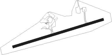
Kenora
Airport details
| Country | Canada |
| State | Ontario |
| Region | CY |
| Airspace | Winnipeg Ctr |
| Municipality | Kenora |
| Elevation | 1345ft (410m) |
| Timezone | GMT -6 |
| Coordinates | 49.78833, -94.36311 |
| Magnetic var | |
| Type | land |
| Available since | X-Plane v10.40 |
| ICAO code | CYQK |
| IATA code | YQK |
| FAA code | n/a |
Communication
| Kenora CTAF | 122.200 |
Nearby beacons
| code | identifier | dist | bearing | frequency |
|---|---|---|---|---|
| YQK | KENORA NDB | 2.3 | 274° | 326 |
| VBI | SIOUX NARROWS VOR/DME | 22.3 | 135° | 115.20 |
| SW | ROADD (WARROAD) NDB | 65.3 | 224° | 360 |
Instrument approach procedures
| runway | airway (heading) | route (dist, bearing) |
|---|---|---|
| RW08 | METVO (98°) | METVO LOPLU (5mi, 161°) 2700ft |
| RW08 | NAKVI (63°) | NAKVI LOPLU (5mi, 341°) 2700ft |
| RNAV | LOPLU 2700ft ROVKA (6mi, 82°) 2700ft PENLI (2mi, 82°) 2110ft CYQK (3mi, 82°) 1375ft XIBED (5mi, 82°) 2900ft XIBED (turn) | |
| RW26 | AMBAP (243°) | AMBAP ELVOL (5mi, 161°) 2900ft |
| RW26 | DUVOX (278°) | DUVOX ELVOL (5mi, 341°) 2900ft |
| RNAV | ELVOL 2900ft HENTY (6mi, 262°) 2700ft CYQK (5mi, 262°) 1382ft MIKLL (5mi, 262°) 2900ft MIKLL (turn) |
Disclaimer
The information on this website is not for real aviation. Use this data with the X-Plane flight simulator only! Data taken with kind consent from X-Plane 12 source code and data files. Content is subject to change without notice.
