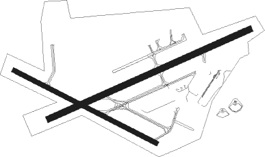
Thunder Bay
Airport details
| Country | Canada |
| State | Ontario |
| Region | CY |
| Airspace | Winnipeg Ctr |
| Municipality | Thunder Bay |
| Elevation | 651ft (198m) |
| Timezone | GMT -5 |
| Coordinates | 48.37200, -89.32171 |
| Magnetic var | |
| Type | land |
| Available since | X-Plane v10.40 |
| ICAO code | CYQT |
| IATA code | YQT |
| FAA code | n/a |
Communication
| Thunder Bay CYQT ATIS | 128.800 |
| Thunder Bay CYQT Ground | 121.300 |
| Thunder Bay CYQT Tower | 118.100 |
Approach frequencies
| ILS-cat-I | RW07 | 109.5 | 18.00mi |
| 3° GS | RW07 | 109.5 | 18.00mi |
Nearby beacons
| code | identifier | dist | bearing | frequency |
|---|---|---|---|---|
| UAU | MCKAY (THUNDER BAY) TACAN | 0.2 | 281° | 112.50 |
| ZQT | SUPERIOR (THUNDER BAY) NDB | 4 | 76° | 263 |
| QT | THUNDER BAY NDB | 4.7 | 257° | 332 |
| YQT | THUNDER BAY VOR/DME | 8.4 | 224° | 114.10 |
Departure and arrival routes
| Transition altitude | 18000ft |
| Transition level | 18000ft |
| SID end points | distance | outbound heading | |
|---|---|---|---|
| RW07 | |||
| NUBOM1 | 100mi | 104° | |
| CYQT8 | 11mi | 250° | |
| RW25 | |||
| LESIS1 | 99mi | 111° | |
| CYQT8 | 11mi | 250° | |
| RW30 | |||
| LESIS1 | 99mi | 111° | |
| CYQT8 | 11mi | 250° | |
| STAR starting points | distance | inbound heading | |
|---|---|---|---|
| RW07 | |||
| TIGAG2 | 29.0 | 98° | |
| LIBUK2 | 28.9 | 137° | |
| NOTER3 | 29.2 | 282° | |
| RW12 | |||
| TIGAG2 | 29.0 | 98° | |
| LIBUK2 | 28.9 | 137° | |
| NOTER3 | 29.2 | 282° | |
| RW25 | |||
| TIGAG2 | 29.0 | 98° | |
| LIBUK2 | 28.9 | 137° | |
| NOTER3 | 29.2 | 282° | |
Instrument approach procedures
| runway | airway (heading) | route (dist, bearing) |
|---|---|---|
| RW07-Y | DURIT (90°) | DURIT 6000ft ULILO (11mi, 96°) 2400ft GONEV (1mi, 86°) 2100ft |
| RW07-Y | FESET (77°) | FESET 3000ft OBMUT (4mi, 77°) 2300ft GONEV (2mi, 77°) 2100ft |
| RW07-Y | MIXEB (16°) | MIXEB 5000ft VIDPO (4mi, 295°) 3700ft DUNPO (3mi, 330°) 2800ft GONEV (2mi, 53°) 2100ft |
| RNAV | GONEV 2100ft CYQT (5mi, 77°) 699ft KANEV (11mi, 77°) 4000ft KANEV (turn) | |
| RW07-Z | KEBTU (56°) | KEBTU 4000ft FESET (5mi, 332°) 3000ft |
| RW07-Z | NUBEN (94°) | NUBEN 4000ft FESET (5mi, 152°) 3000ft |
| RNAV | FESET 3000ft OBMUT (4mi, 77°) 2800ft GONEV (2mi, 77°) 2100ft CYQT (5mi, 77°) 699ft KANEV (11mi, 77°) 4000ft KANEV (turn) | |
| RW12-X | DEPLI (134°) | DEPLI 4000ft MOGOV (5mi, 222°) 3000ft |
| RW12-X | SUTUK (94°) | SUTUK 4000ft MOGOV (5mi, 42°) 3000ft |
| RNAV | MOGOV 3000ft LOLVA (5mi, 112°) 2200ft CYQT (5mi, 110°) 697ft ETGIM (11mi, 87°) 4000ft ETGIM (turn) | |
| RW12-Z | DEPLI (134°) | DEPLI 4000ft MOGOV (5mi, 222°) 3000ft |
| RW12-Z | SUTUK (94°) | SUTUK 4000ft MOGOV (5mi, 42°) 3000ft |
| RNAV | MOGOV 3000ft LOLVA (5mi, 112°) 2200ft XOTUV (1mi, 112°) 1700ft OMPUN (1mi, 112°) 1291ft ETGIM (13mi, 91°) 4000ft ETGIM (turn) | |
| RW25-Y | KANEV (257°) | KANEV 3400ft NAGAG (4mi, 257°) 2000ft BEROB (2mi, 257°) 2000ft |
| RW25-Y | UKRED (209°) | UKRED 5000ft LOLPO (2mi, 77°) 4400ft MIRIL (4mi, 108°) 3200ft NAGAG (4mi, 216°) 2000ft BEROB (2mi, 257°) 2000ft |
| RW25-Y | VIVUR (271°) | VIVUR 5500ft AVTIT (10mi, 278°) 2400ft BEROB (1mi, 267°) 2000ft |
| RNAV | BEROB 2000ft CYQT (5mi, 256°) 685ft FESET (10mi, 257°) 4000ft FESET (turn) | |
| RW25-Z | EBKIL (274°) | EBKIL 4000ft KANEV (5mi, 332°) 3400ft |
| RW25-Z | GABUR (237°) | GABUR 4000ft KANEV (5mi, 152°) 3400ft |
| RNAV | KANEV 3400ft BEROB (6mi, 257°) 2000ft VEPVI (2mi, 257°) 1340ft CYQT (3mi, 256°) 685ft FESET (10mi, 257°) 4000ft FESET (turn) |
Disclaimer
The information on this website is not for real aviation. Use this data with the X-Plane flight simulator only! Data taken with kind consent from X-Plane 12 source code and data files. Content is subject to change without notice.

