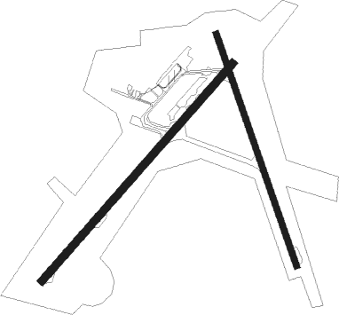
Sydney - Sydney / Mccurdy
Airport details
| Country | Canada |
| State | Nova Scotia |
| Region | CY |
| Airspace | Moncton Ctr |
| Municipality | Reserve Mines |
| Elevation | 203ft (62m) |
| Timezone | GMT -4 |
| Coordinates | 46.16152, -60.04805 |
| Magnetic var | |
| Type | land |
| Available since | X-Plane v10.40 |
| ICAO code | CYQY |
| IATA code | YQY |
| FAA code | YQY |
Communication
Approach frequencies
| ILS-cat-I | RW06 | 110.3 | 18.00mi |
| 3° GS | RW06 | 110.3 | 18.00mi |
Nearby beacons
| code | identifier | dist | bearing | frequency |
|---|---|---|---|---|
| YQY | SYDNEY VOR/DME | 0.5 | 223° | 114.90 |
| QY | SYDNEY NDB | 4.2 | 55° | 263 |
Departure and arrival routes
| Transition altitude | 18000ft |
| Transition level | 18000ft |
| SID end points | distance | outbound heading | |
|---|---|---|---|
| RW06 | |||
| CYQY5 | 104mi | 315° | |
| RW18 | |||
| CYQY5 | 104mi | 315° | |
| RW24 | |||
| CYQY5 | 104mi | 315° | |
| RW36 | |||
| CYQY5 | 104mi | 315° | |
Instrument approach procedures
| runway | airway (heading) | route (dist, bearing) |
|---|---|---|
| RW06-Y | MITOX (56°) | MITOX 3000ft LOMVU (6mi, 56°) 1400ft |
| RW06-Y | NUBUG (79°) | NUBUG 5000ft ETGEN (10mi, 89°) 1900ft LOMVU (2mi, 73°) 1400ft |
| RW06-Y | VOKUR (308°) | VOKUR 5000ft VOBEB (5mi, 256°) 3400ft LOMVU (5mi, 318°) 1400ft |
| RNAV | LOMVU 1400ft CYQY (4mi, 56°) 242ft GAGBU (10mi, 56°) 3000ft GAGBU (turn) | |
| RW06-Z | LESUP (76°) | LESUP 3000ft MITOX (5mi, 125°) 2500ft |
| RW06-Z | VIPKO (29°) | VIPKO 3000ft MITOX (5mi, 306°) 2500ft |
| RNAV | MITOX 2500ft MOBUX (6mi, 56°) 1600ft APKEB (3mi, 56°) 720ft CYQY (2mi, 57°) 242ft GAGBU (10mi, 56°) 3000ft GAGBU (turn) | |
| RW18-Y | KINIP (162°) | KINIP 3000ft MEVTA (6mi, 159°) 1600ft |
| RW18-Y | NOTIK (110°) | NOTIK 5000ft PEVPI (8mi, 87°) 2600ft MEVTA (3mi, 117°) 1600ft |
| RW18-Y | VOGUB (95°) | VOGUB 5000ft OTPUB (6mi, 55°) 3100ft PEVPI (2mi, 73°) 2600ft MEVTA (3mi, 117°) 1600ft |
| RNAV | MEVTA 1600ft CYQY (5mi, 166°) 242ft ALVUX (11mi, 157°) 3000ft ALVUX (turn) | |
| RW18-Z | DUSAP (131°) | DUSAP 3000ft KINIP (5mi, 80°) 2000ft |
| RW18-Z | GUBIB (198°) | GUBIB 3000ft KINIP (5mi, 260°) 2000ft |
| RNAV | KINIP 2000ft OTPOB (6mi, 159°) 1600ft CYQY (5mi, 166°) 242ft ALVUX (11mi, 157°) 3000ft ALVUX (turn) | |
| RW24-Y | AVSED (310°) | AVSED 5000ft IRLUG (4mi, 56°) 3700ft USBOM (5mi, 306°) 1300ft |
| RW24-Y | GAGBU (236°) | GAGBU 3000ft USBOM (7mi, 236°) 1300ft |
| RW24-Y | TUDUK (126°) | TUDUK 5000ft OMSEG (5mi, 76°) 3400ft USBOM (5mi, 138°) 1300ft |
| RNAV | USBOM 1300ft CYQY (4mi, 236°) 244ft MITOX (11mi, 236°) 3000ft MITOX (turn) | |
| RW24-Z | LERES (257°) | LERES 3000ft GAGBU (5mi, 306°) 2000ft |
| RW24-Z | OBVUP (208°) | OBVUP 3000ft GAGBU (5mi, 126°) 2000ft |
| RNAV | GAGBU 2000ft EBLUG (6mi, 236°) 1600ft CYQY (5mi, 236°) 244ft MITOX (11mi, 236°) 3000ft MITOX (turn) | |
| RW36-Y | ALVUX (337°) | ALVUX 3000ft OTOXI (7mi, 339°) 1300ft |
| RW36-Y | ITNAV (26°) | ITNAV 5000ft OVEBU (10mi, 45°) 1900ft OTOXI (2mi, 15°) 1300ft |
| RW36-Y | URVUB (61°) | URVUB 5000ft ENADU (8mi, 89°) 2600ft OVEBU (2mi, 70°) 1900ft OTOXI (2mi, 15°) 1300ft |
| RNAV | OTOXI 1300ft CYQY (4mi, 332°) 239ft KINIP (10mi, 342°) 3000ft KINIP (turn) | |
| RW36-Z | LEXUN (13°) | LEXUN 3000ft ALVUX (5mi, 80°) 2000ft |
| RW36-Z | OGDAN (308°) | OGDAN 3000ft ALVUX (5mi, 260°) 2000ft |
| RNAV | ALVUX 2000ft DAVUD (6mi, 339°) 1600ft XOROT (3mi, 339°) 720ft CYQY (2mi, 326°) 239ft KINIP (10mi, 342°) 3000ft KINIP (turn) |
Disclaimer
The information on this website is not for real aviation. Use this data with the X-Plane flight simulator only! Data taken with kind consent from X-Plane 12 source code and data files. Content is subject to change without notice.

