Ottawa - Carp
Airport details
| Country | Canada |
| State | Ontario |
| Region | CY |
| Airspace | Montreal Ctr |
| Municipality | West Carleton |
| Elevation | 378ft (115m) |
| Timezone | GMT -5 |
| Coordinates | 45.31917, -76.02222 |
| Magnetic var | |
| Type | land |
| Available since | X-Plane v10.40 |
| ICAO code | CYRP |
| IATA code | n/a |
| FAA code | n/a |
Communication
| Carp ATIS | 121.150 |
| Carp CTAF/UNICOM | 122.800 |
| Carp OTTAWA TRML | 128.175 |
Nearby Points of Interest:
Burnt Lands alvar
-Horaceville, Ottawa
-93, rue Court
-Panmure Alvar
-Pakenham Bridge
-Carleton Place railway station
-Kilmorie house
-The Farm
-Riverview
-Main Building
-K.W. Neatby Building
-Salaberry Armoury
-Sir John Carling Building
-Sir Charles Tupper Building
-Edward Drake Building
-Supreme Court Building
-Justice Building
-caserne numéro 3
-Confederation Building
-Wellington Building
-National Press Building
-Sir John A. Macdonald Building
-Victoria Building
-Scottish Ontario Chambers
-Bell Block
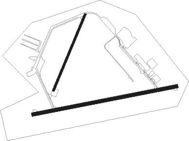
Runway info
Runway 04 / 22  | ||
| length | 674m (2211ft) | |
| bearing | 36° / 216° | |
| width | 20m (65ft) | |
| surface | gravel | |
| displ threshold | 53m (174ft) / 31m (102ft) | |
| blast zone | 48m (157ft) / 0m (0ft) | |
| Runway 10 / 28 | ||
| length | 1197m (3927ft) | |
| bearing | 85° / 265° | |
| width | 30m (98ft) | |
| surface | asphalt | |
Nearby beacons
| code | identifier | dist | bearing | frequency |
|---|---|---|---|---|
| YOW | OTTAWA VOR/DME | 9 | 46° | 114.60 |
| OW | OTTAWA NDB | 19.6 | 85° | 236 |
| OG | OGIVE (OGDENSBURG) NDB | 46.7 | 133° | 358 |
| YMW | MANIWAKI NDB | 53.4 | 4° | 366 |
Instrument approach procedures
| runway | airway (heading) | route (dist, bearing) |
|---|---|---|
| RW10 | ESRUV (105°) | ESRUV XIKAK (5mi, 171°) 2000ft |
| RW10 | XEVUD (65°) | XEVUD XIKAK (5mi, 351°) 2000ft |
| RNAV | XIKAK 2000ft OTIRU (5mi, 85°) 1800ft XOVTU (2mi, 85°) 1070ft CYRP (2mi, 86°) 431ft (4818mi, 121°) 790ft ESRUV (4829mi, 301°) 3000ft ESRUV (turn) |
Disclaimer
The information on this website is not for real aviation. Use this data with the X-Plane flight simulator only! Data taken with kind consent from X-Plane 12 source code and data files. Content is subject to change without notice.