Summerside
Airport details
| Country | Canada |
| State | Prince Edward Island |
| Region | CY |
| Airspace | Moncton Ctr |
| Municipality | Lot 17 |
| Elevation | 56ft (17m) |
| Timezone | GMT -4 |
| Coordinates | 46.44778, -63.82246 |
| Magnetic var | |
| Type | land |
| Available since | X-Plane v10.40 |
| ICAO code | CYSU |
| IATA code | YSU |
| FAA code | n/a |
Communication
| Summerside AWOS | 122.550 |
| Summerside CTAF/UNICOM | 122.950 |
Nearby Points of Interest:
Summerside City Hall
-Summerside station
-Indian Head Lighthouse
-St. Brigid's Church, Prince Edward Island
-Green Gables
-O'Leary railway station
-Alberton Railway Station
-Fort Gaspareaux
-Holy Trinity Anglican Church
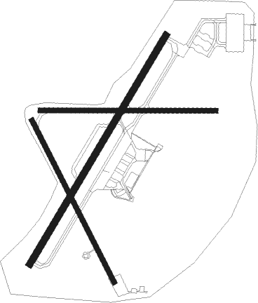
Runway info
Runway 06 / 24  | ||
| length | 2454m (8051ft) | |
| bearing | 46° / 226° | |
| width | 61m (200ft) | |
| surface | asphalt | |
| displ threshold | 9m (30ft) / 2m (7ft) | |
| blast zone | 168m (551ft) / 255m (837ft) | |
| Runway 11 / 29 | ||
| length | 1618m (5308ft) | |
| bearing | 93° / 273° | |
| width | 46m (150ft) | |
| surface | asphalt | |
| blast zone | 61m (200ft) / 61m (200ft) | |
| Runway 18 / 36 | ||
| length | 1672m (5486ft) | |
| bearing | 149° / 329° | |
| width | 46m (150ft) | |
| surface | asphalt | |
| blast zone | 50m (164ft) / 157m (515ft) | |
Nearby beacons
| code | identifier | dist | bearing | frequency |
|---|---|---|---|---|
| 5B | SUMMERSIDE NDB | 3.9 | 229° | 254 |
| YYG | CHARLOTTETOWN VOR/DME | 30.4 | 102° | 113.80 |
| YQM | MONCTON VOR/DME | 34.7 | 251° | 117.30 |
| QM | MONCTON NDB | 37.4 | 246° | 224 |
| ZMN | LEWISVILLE (MONCTON) NDB | 45.2 | 250° | 366 |
| ZQM | RIVERVIEW (MONCTON) NDB | 46.8 | 247° | 304 |
Instrument approach procedures
| runway | airway (heading) | route (dist, bearing) |
|---|---|---|
| RW05 | KEBOS (66°) | KEBOS ITNAG (5mi, 116°) 1600ft |
| RW05 | LERUL (21°) | LERUL ITNAG (5mi, 296°) 1600ft |
| RNAV | ITNAG 1600ft DEMRI (7mi, 45°) 1600ft CYSU (6mi, 47°) 98ft URNUT (2mi, 42°) MAVIB (6mi, 46°) 2100ft MAVIB (turn) | |
| RW23 | AVRUN (247°) | AVRUN OMSAR (5mi, 296°) 1600ft |
| RW23 | MAVAG (197°) | MAVAG OMSAR (5mi, 116°) 1600ft |
| RNAV | OMSAR 1600ft KERPA (7mi, 226°) 1600ft CYSU (5mi, 224°) 83ft VESLA (3mi, 228°) TOTEN (6mi, 226°) 2100ft TOTEN (turn) |
Disclaimer
The information on this website is not for real aviation. Use this data with the X-Plane flight simulator only! Data taken with kind consent from X-Plane 12 source code and data files. Content is subject to change without notice.