London - London Ontario
Airport details
| Country | Canada |
| State | Ontario |
| Region | CY |
| Airspace | Toronto Ctr |
| Municipality | London |
| Elevation | 912ft (278m) |
| Timezone | GMT -5 |
| Coordinates | 43.03305, -81.15100 |
| Magnetic var | |
| Type | land |
| Available since | X-Plane v10.40 |
| ICAO code | CYXU |
| IATA code | YXU |
| FAA code | YXU |
Communication
| London Ontario ATIS | 127.800 |
| London Ontario Ground Control | 121.900 |
| London Ontario Tower | 119.400 |
Approach frequencies
| ILS-cat-I | RW15 | 109.5 | 18.00mi |
| 3° GS | RW15 | 109.5 | 18.00mi |
Nearby Points of Interest:
London Normal School
-Canada Southern Railway Station
-BX InterlockingTower
-Old Woodstock Town Hall
-Annandale National Historic Site
-Port Stanley
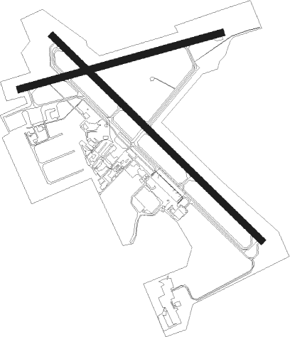
Runway info
Runway 15 / 33  | ||
| length | 2685m (8809ft) | |
| bearing | 130° / 310° | |
| width | 61m (200ft) | |
| surface | asphalt | |
| blast zone | 40m (131ft) / 45m (148ft) | |
| Runway 09 / 27 | ||
| length | 1916m (6286ft) | |
| bearing | 82° / 262° | |
| width | 61m (200ft) | |
| surface | asphalt | |
Nearby beacons
| code | identifier | dist | bearing | frequency |
|---|---|---|---|---|
| YXU | LONDON VOR/DME | 0.3 | 23° | 117.20 |
| FD | BRANTFORD NDB | 32.3 | 87° | 207 |
| WT | (KITCHENER) DME | 42.3 | 61° | 115 |
| ZKF | WELLINGTON (KITCHENER) NDB | 46.8 | 62° | 335 |
Departure and arrival routes
| Transition altitude | 18000ft |
| Transition level | 18000ft |
| SID end points | distance | outbound heading | |
|---|---|---|---|
| RW09 | |||
| CYXU2 | 69mi | 343° | |
| RW15 | |||
| CYXU2 | 69mi | 343° | |
| RW27 | |||
| CYXU2 | 69mi | 343° | |
| RW33 | |||
| CYXU2 | 69mi | 343° | |
Instrument approach procedures
| runway | airway (heading) | route (dist, bearing) |
|---|---|---|
| RW09 | ALITI (63°) | ALITI 3000ft VIMSA (5mi, 345°) 3000ft |
| RW09 | BEMIK (102°) | BEMIK 3000ft VIMSA (5mi, 165°) 3000ft |
| RNAV | VIMSA 3000ft KIXIV (7mi, 82°) 2000ft CYXU (4mi, 86°) 952ft GOTOL (11mi, 80°) 4000ft GOTOL (turn) | |
| RW15-Y | ATUKO (111°) | ATUKO 4000ft XUDPU (5mi, 97°) 2600ft ITLOL (2mi, 112°) 2100ft |
| RW15-Y | EMOKI (177°) | EMOKI 4000ft UKOVO (3mi, 237°) 3200ft ITLOL (4mi, 185°) 2100ft |
| RW15-Y | TUDAR (130°) | TUDAR 3000ft ITLOL (6mi, 130°) 2100ft |
| RNAV | ITLOL 2100ft CYXU (4mi, 131°) 955ft DAVOK (11mi, 129°) 4000ft DAVOK (turn) | |
| RW15-Z | OLEXI (160°) | OLEXI 3000ft TUDAR (5mi, 237°) 3000ft |
| RW15-Z | URLOS (107°) | URLOS 3000ft TUDAR (5mi, 57°) 3000ft |
| RNAV | TUDAR 3000ft ITLOL (6mi, 130°) 2100ft XOSPA (2mi, 130°) 1400ft CYXU (2mi, 132°) 955ft DAVOK (11mi, 129°) 4000ft DAVOK (turn) | |
| RW27 | GOPEX (240°) | GOPEX 3000ft GOTOL (5mi, 165°) 3000ft |
| RW27 | ONDUL (279°) | ONDUL 3000ft GOTOL (5mi, 345°) 3000ft |
| RNAV | GOTOL 3000ft OTNUP (7mi, 262°) 2000ft CYXU (4mi, 257°) 946ft VIMSA (10mi, 263°) 4000ft VIMSA (turn) | |
| RW33-Y | BIVTO (247°) | BIVTO 5000ft XOPGA (3mi, 130°) 4200ft NAGEB (4mi, 185°) 3100ft NORAP (4mi, 273°) 2000ft |
| RW33-Y | DAVOK (309°) | DAVOK 3000ft NORAP (7mi, 310°) 2000ft |
| RW33-Y | IRDEN (276°) | IRDEN 4000ft NAGEB (3mi, 237°) 3100ft NORAP (4mi, 273°) 2000ft |
| RW33-Y | TADOM (6°) | TADOM 4000ft XUBET (4mi, 57°) 2900ft NORAP (3mi, 5°) 2000ft |
| RNAV | NORAP 2000ft CYXU (4mi, 309°) 955ft TUDAR (10mi, 310°) 4000ft TUDAR (turn) | |
| RW33-Z | KERPO (288°) | KERPO 3000ft DAVOK (5mi, 237°) 3000ft |
| RW33-Z | LOMSU (338°) | LOMSU 3000ft DAVOK (5mi, 57°) 3000ft |
| RNAV | DAVOK 3000ft NORAP (7mi, 310°) 2000ft XOXAS (2mi, 310°) 1450ft CYXU (2mi, 308°) 955ft TUDAR (10mi, 310°) 4000ft TUDAR (turn) |
Disclaimer
The information on this website is not for real aviation. Use this data with the X-Plane flight simulator only! Data taken with kind consent from X-Plane 12 source code and data files. Content is subject to change without notice.