North Bay - North Bay Jack Garland
Airport details
| Country | Canada |
| State | Ontario |
| Region | CY |
| Airspace | Toronto Ctr |
| Municipality | North Bay |
| Elevation | 1213ft (370m) |
| Timezone | GMT -5 |
| Coordinates | 46.35751, -79.42958 |
| Magnetic var | |
| Type | land |
| Available since | X-Plane v10.40 |
| ICAO code | CYYB |
| IATA code | YYB |
| FAA code | n/a |
Communication
| North Bay Jack Garland ATIS | 124.900 |
| North Bay Jack Garland RCO (London) | 126.700 |
| North Bay Jack Garland Shell Jet A - 100LL | 122.950 |
| North Bay Jack Garland Esso Jet A | 131.750 |
| North Bay Jack Garland Tower | 118.300 |
| North Bay Jack Garland PALToronto Ctr | 127.250 |
Approach frequencies
| ILS-cat-I | RW08 | 110.9 | 18.00mi |
| 3° GS | RW08 | 110.9 | 18.00mi |
Nearby Points of Interest:
Témiscaming station
Runway info
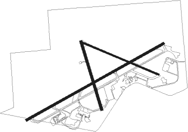
Runway 08 / 26  | ||
| length | 3043m (9984ft) | |
| bearing | 72° / 252° | |
| width | 43m (140ft) | |
| surface | asphalt | |
| Runway 18 / 36 | ||
| length | 1372m (4501ft) | |
| bearing | 162° / 342° | |
| width | 46m (151ft) | |
| surface | asphalt | |
| blast zone | 0m (0ft) / 61m (200ft) | |
| Runway 13 / 31 | ||
| length | 1582m (5190ft) | |
| bearing | 110° / 290° | |
| width | 30m (100ft) | |
| surface | asphalt | |
| blast zone | 114m (374ft) / 211m (692ft) | |
Nearby beacons
| code | identifier | dist | bearing | frequency |
|---|---|---|---|---|
| YYB | NORTH BAY VOR/DME | 0.4 | 313° | 115.40 |
Instrument approach procedures
| runway | airway (heading) | route (dist, bearing) |
|---|---|---|
| RW08 | DEGDA (49°) | DEGDA LEPIK (5mi, 326°) 2500ft |
| RW08 | GUDIK (93°) | GUDIK LEPIK (5mi, 146°) 2500ft |
| RNAV | LEPIK 2500ft EBDAN (5mi, 72°) 2500ft CYYB (5mi, 74°) 1209ft MUXUS (5mi, 70°) 2900ft MUXUS (turn) | |
| RW18 | ITGAN (199°) | ITGAN KEVBA (5mi, 261°) 2600ft |
| RW18 | ODKOB (133°) | ODKOB KEVBA (5mi, 81°) 2600ft |
| RNAV | KEVBA 2600ft NORUX (6mi, 162°) 2500ft CYYB (5mi, 167°) 1225ft UDBUM (4mi, 157°) 2900ft UDBUM (turn) | |
| RW26 | EMASI (229°) | EMASI SEBAB (5mi, 147°) 2600ft |
| RW26 | TIBEM (270°) | TIBEM SEBAB (5mi, 327°) 2600ft |
| RNAV | SEBAB 2600ft MUSIX (5mi, 253°) 2600ft CYYB (5mi, 251°) 1265ft NOTOD (4mi, 255°) 2900ft NOTOD (turn) | |
| RW36 | IMELI (307°) | IMELI PUTAD (5mi, 261°) 2500ft |
| RW36 | OBTOP (21°) | OBTOP PUTAD (5mi, 81°) 2500ft |
| RNAV | PUTAD 2500ft KEGSA (5mi, 342°) 2500ft XORIB (2mi, 342°) 1830ft CYYB (2mi, 332°) 1222ft UDPET (5mi, 347°) 2900ft UDPET (turn) |
Disclaimer
The information on this website is not for real aviation. Use this data with the X-Plane flight simulator only! Data taken with kind consent from X-Plane 12 source code and data files. Content is subject to change without notice.