Goose Bay
Airport details
| Country | Canada |
| State | Newfoundland and Labrador |
| Region | CY |
| Airspace | Gander Oceanic Ctr |
| Municipality | Happy Valley-Goose Bay |
| Elevation | 160ft (49m) |
| Timezone | GMT -4 |
| Coordinates | 53.31917, -60.42583 |
| Magnetic var | |
| Type | land |
| Available since | X-Plane v10.40 |
| ICAO code | CYYR |
| IATA code | YYR |
| FAA code | n/a |
Communication
| Goose Bay ATIS | 128.100 |
| Goose Bay Clearance DEL | 118.100 |
| Goose Bay Ground Control | 121.900 |
| Goose Bay Tower | 119.100 |
| Goose Bay PAR | 119.900 |
| Goose Bay PAR | 124.500 |
| Goose Bay TRML | 119.500 |
| Goose Bay Departure | 119.500 |
Approach frequencies
| ILS-cat-I | RW08 | 110.3 | 18.00mi |
| 3° GS | RW08 | 110.3 | 18.00mi |
Runway info
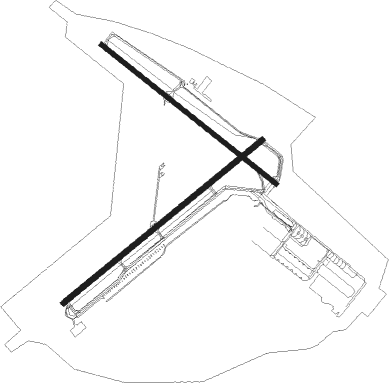
Runway 08 / 26  | ||
| length | 3357m (11014ft) | |
| bearing | 67° / 247° | |
| width | 64m (209ft) | |
| surface | asphalt | |
| blast zone | 255m (837ft) / 255m (837ft) | |
| Runway 16 / 34 | ||
| length | 2922m (9587ft) | |
| bearing | 119° / 299° | |
| width | 61m (200ft) | |
| surface | asphalt | |
| blast zone | 46m (151ft) / 152m (499ft) | |
Nearby beacons
| code | identifier | dist | bearing | frequency |
|---|---|---|---|---|
| UYR | GOOSE (GOOSE BAY) TACAN | 0.3 | 87° | 110.30 |
| YR | GOOSE (GOOSE BAY) NDB | 2.4 | 73° | 257 |
| YYR | GOOSE (GOOSE BAY) VOR/DME | 4.7 | 90° | 117.30 |
Instrument approach procedures
| runway | airway (heading) | route (dist, bearing) |
|---|---|---|
| RW08 | ALOGU (67°) | ALOGU LESIX (5mi, 67°) 2800ft |
| RW08 | BADDY (81°) | BADDY LESIX (6mi, 131°) 2800ft |
| RW08 | DAVIG (47°) | DAVIG LESIX (6mi, 311°) 2800ft |
| RNAV | LESIX 2800ft FAFKO (6mi, 67°) 2800ft SATAK (3mi, 67°) 1810ft KIVAV (3mi, 67°) 790ft CYYR (3mi, 63°) 214ft DUXUR (14mi, 69°) 3200ft DUXUR (turn) | |
| RW16 | BOGPI (150°) | BOGPI LIBOD (6mi, 237°) 3100ft |
| RW16 | IGVES (101°) | IGVES LIBOD (6mi, 57°) 3100ft |
| RW16 | KEDAL (120°) | KEDAL LIBOD (5mi, 119°) 3100ft |
| RNAV | LIBOD 3100ft NOVOV (6mi, 119°) 1900ft ALRER (2mi, 119°) 1350ft METGI (2mi, 119°) 710ft CYYR (3mi, 128°) 200ft BOKBU (14mi, 118°) 3200ft BOKBU (turn) | |
| RW26 | MASIN (265°) | MASIN BAJER (5mi, 311°) 1900ft |
| RW26 | RADUL (226°) | RADUL BAJER (5mi, 131°) 1900ft |
| RW26 | SCOAT (248°) | SCOAT BAJER (5mi, 248°) 1900ft |
| RNAV | BAJER 1900ft DATKA (6mi, 248°) 1900ft CYYR (6mi, 250°) 205ft TALOV (14mi, 236°) 3200ft TALOV (turn) | |
| RW34 | BOGLO (298°) | BOGLO DUMRO (5mi, 299°) 3100ft |
| RW34 | GOXOP (279°) | GOXOP DUMRO (6mi, 237°) 3100ft |
| RW34 | NABUB (326°) | NABUB DUMRO (6mi, 57°) 3100ft |
| RNAV | DUMRO 3100ft EBMEB (6mi, 299°) 1900ft CYYR (6mi, 296°) 196ft NABTU (14mi, 300°) 3200ft NABTU (turn) |
Disclaimer
The information on this website is not for real aviation. Use this data with the X-Plane flight simulator only! Data taken with kind consent from X-Plane 12 source code and data files. Content is subject to change without notice.