Yellowknife
Airport details
| Country | Canada |
| State | Northwest Territories |
| Region | CY |
| Airspace | Edmonton Ctr |
| Municipality | Yellowknife |
| Elevation | 671ft (205m) |
| Timezone | GMT -7 |
| Coordinates | 62.46305, -114.44028 |
| Magnetic var | |
| Type | land |
| Available since | X-Plane v10.40 |
| ICAO code | CYZF |
| IATA code | YZF |
| FAA code | n/a |
Communication
| Yellowknife ATIS | 128.400 |
| Yellowknife MF | 118.500 |
| Yellowknife Ground Control | 121.900 |
| Yellowknife Tower | 118.500 |
| Yellowknife EDMONTON CTR | 135.800 |
Approach frequencies
| ILS-cat-I | RW34 | 109.5 | 18.00mi |
| 3° GS | RW34 | 109.5 | 18.00mi |
Nearby Points of Interest:
Fireweed Studio
-Yellowknife Post Office
-Weaver & Devore Trading
-Canadian Pacific Airlines floatbase
-Hudson's Bay Warehouse
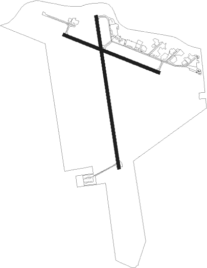
Runway info
Runway 16 / 34  | ||
| length | 2289m (7510ft) | |
| bearing | 171° / 351° | |
| width | 46m (150ft) | |
| surface | asphalt | |
| Runway 10 / 28 | ||
| length | 1526m (5007ft) | |
| bearing | 103° / 283° | |
| width | 46m (150ft) | |
| surface | asphalt | |
Nearby beacons
| code | identifier | dist | bearing | frequency |
|---|---|---|---|---|
| YZF | YELLOWKNIFE VORTAC | 0.1 | 71° | 115.50 |
| ZF | YELLOWKNIFE NDB | 3.1 | 174° | 356 |
Instrument approach procedures
| runway | airway (heading) | route (dist, bearing) |
|---|---|---|
| RW10-Y | BESUT (103°) | BESUT 2000ft ADRIS (6mi, 103°) 2000ft |
| RW10-Y | URMAG (73°) | URMAG 5000ft KEBVO (5mi, 353°) 3500ft MIRUB (1mi, 21°) 3200ft ADRIS (4mi, 80°) 2000ft |
| RW10-Y | VOGID (78°) | VOGID 5000ft MIRUB (6mi, 43°) 3200ft ADRIS (4mi, 80°) 2000ft |
| RNAV | ADRIS 2000ft CYZF (5mi, 105°) 723ft VOLOS (10mi, 102°) 4000ft VOLOS (turn) | |
| RW10-Z | DAXAX (91°) | DAXAX BESUT (5mi, 46°) 2000ft |
| RW10-Z | TADOL (121°) | TADOL BESUT (5mi, 226°) 2000ft |
| RNAV | BESUT 2000ft ADRIS (6mi, 103°) 2000ft CYZF (5mi, 105°) 723ft VOLOS (10mi, 102°) 4000ft VOLOS (turn) | |
| RW16-Y | ADSAL (171°) | ADSAL 2000ft RADIR (6mi, 171°) 2000ft |
| RW16-Y | OVDOP (257°) | OVDOP 5000ft KEDIT (2mi, 352°) 4400ft RADIR (5mi, 268°) 2000ft |
| RW16-Y | SIBKO (99°) | SIBKO 5000ft MIRUV (2mi, 351°) 4400ft RADIR (5mi, 88°) 2000ft |
| RNAV | RADIR 2000ft CYZF (5mi, 170°) 726ft OMTAX (11mi, 172°) 4000ft OMTAX (turn) | |
| RW16-Z | ALERU (129°) | ALERU ADSAL (5mi, 88°) 2100ft |
| RW16-Z | NALVO (220°) | NALVO ADSAL (5mi, 268°) 2100ft |
| RNAV | ADSAL 2100ft RADIR (6mi, 171°) 2000ft CYZF (5mi, 170°) 726ft OMTAX (11mi, 172°) 4000ft OMTAX (turn) | |
| RW28-Y | PEVKI (310°) | PEVKI 5000ft MIVUX (7mi, 350°) 2800ft ULEXA (2mi, 304°) 2000ft |
| RW28-Y | VOLOS (282°) | VOLOS 2000ft ULEXA (6mi, 283°) 2000ft |
| RNAV | ULEXA 2000ft CYZF (4mi, 281°) 726ft BESUT (11mi, 283°) 4000ft BESUT (turn) | |
| RW28-Z | WHEGE (300°) | WHEGE VOLOS (5mi, 47°) 2000ft |
| RW28-Z | XULBU (270°) | XULBU VOLOS (5mi, 227°) 2000ft |
| RNAV | VOLOS 2000ft ULEXA (6mi, 283°) 2000ft DUPTU (3mi, 283°) 1110ft CYZF (1mi, 277°) 726ft BESUT (11mi, 283°) 4000ft BESUT (turn) | |
| RW34-Y | OMTAX (352°) | OMTAX 2100ft MAVUG (6mi, 351°) 2000ft |
| RW34-Y | RUBTI (25°) | RUBTI 4000ft KIXUK (5mi, 46°) 2400ft MAVUG (1mi, 22°) 2000ft |
| RNAV | MAVUG 2000ft CYZF (5mi, 353°) 713ft ADSAL (11mi, 351°) 4000ft ADSAL (turn) | |
| RW34-Z | IGROP (40°) | IGROP OMTAX (5mi, 88°) 2100ft |
| RW34-Z | PEPGA (310°) | PEPGA OMTAX (5mi, 268°) 2100ft |
| RNAV | OMTAX 2100ft MAVUG (6mi, 351°) 2000ft LOGTA (3mi, 351°) 1190ft CYZF (2mi, 355°) 713ft ADSAL (11mi, 351°) 4000ft ADSAL (turn) |
Disclaimer
The information on this website is not for real aviation. Use this data with the X-Plane flight simulator only! Data taken with kind consent from X-Plane 12 source code and data files. Content is subject to change without notice.