Bottineau - Bottineau Muni
Airport details
| Country | United States of America |
| State | North Dakota |
| Region | K3 |
| Airspace | Minneapolis Ctr |
| Municipality | Bottineau County |
| Elevation | 1680ft (512m) |
| Timezone | GMT -6 |
| Coordinates | 48.83047, -100.41730 |
| Magnetic var | |
| Type | land |
| Available since | X-Plane v10.40 |
| ICAO code | D09 |
| IATA code | n/a |
| FAA code | n/a |
Communication
| Bottineau Muni CTAF/UNICOM | 122.800 |
| Bottineau Muni MINOT Approach | 119.600 |
| Bottineau Muni MINOT Departure | 119.600 |
Nearby Points of Interest:
Old Main
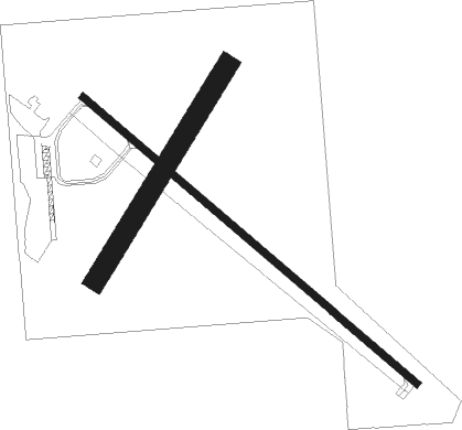
Runway info
Runway 13 / 31  | ||
| length | 1129m (3704ft) | |
| bearing | 124° / 304° | |
| width | 18m (60ft) | |
| surface | asphalt | |
| Runway 03 / 21 | ||
| length | 646m (2119ft) | |
| bearing | 48° / 228° | |
| width | 52m (170ft) | |
| surface | grass | |
Nearby beacons
| code | identifier | dist | bearing | frequency |
|---|---|---|---|---|
| MIB | DEERING (MINOT) TACAN | 45.1 | 246° | 114.90 |
| MOT | MINOT VOR/DME | 48.6 | 237° | 117.10 |
Instrument approach procedures
| runway | airway (heading) | route (dist, bearing) |
|---|---|---|
| RW31 | BALTA (330°) | BALTA SINMU (22mi, 340°) 3500ft VATYY (10mi, 340°) 3500ft |
| RW31 | ZONWY (347°) | ZONWY SINMU (7mi, 88°) 3500ft VATYY (10mi, 340°) 3500ft |
| RNAV | VATYY 3500ft JOPWO (5mi, 304°) 3300ft HIPOV (3mi, 304°) 2300ft D09 (2mi, 304°) 1701ft CUSKI (5mi, 304°) WUTUT (10mi, 237°) ZONWY (19mi, 124°) 3900ft ZONWY (turn) |
Disclaimer
The information on this website is not for real aviation. Use this data with the X-Plane flight simulator only! Data taken with kind consent from X-Plane 12 source code and data files. Content is subject to change without notice.