Lapeer - Dupont Lapeer
Airport details
| Country | United States of America |
| State | Michigan |
| Region | K5 |
| Airspace | Cleveland Ctr |
| Municipality | Mayfield Township |
| Elevation | 833ft (254m) |
| Timezone | GMT -5 |
| Coordinates | 43.06647, -83.27155 |
| Magnetic var | |
| Type | land |
| Available since | X-Plane v10.40 |
| ICAO code | D95 |
| IATA code | n/a |
| FAA code | n/a |
Communication
| Dupont Lapeer CTAF/UNICOM | 123.000 |
| Dupont Lapeer FLINT Approach/Departure | 118.800 |
| Dupont Lapeer FLINT Approach/Departure | 128.550 |
Nearby Points of Interest:
Peter Van Dyke House
-Lapeer County Courthouse
-Rodney G. Hart House
-William H. and Sabrina Watson House
-Samuel J. Tomlinson House
-John and Rosetta Lee House
-James B. Dutton House
-Joseph Armstrong House
-Piety Hill Historic District
-Columbus Tuttle House
-Jay White House
-John and Julia Hevener House
-Warren Perry House
-Metamora Crossroads Historic District
-Detroit–Bay City Railroad Company Columbiaville Depot
-Charles Palmer House
-James F. Fairweather–Jacob C. Lamb House
-John W. Day House
-Hadley Flour and Feed Mill
-House at 1339 Cummings Road
-Younge Site
-Pioneer State Bank No. 36
-E. S. Swayze Drugstore
-John Van Buskirk Farm House
-West Saint Clair Street Historic District
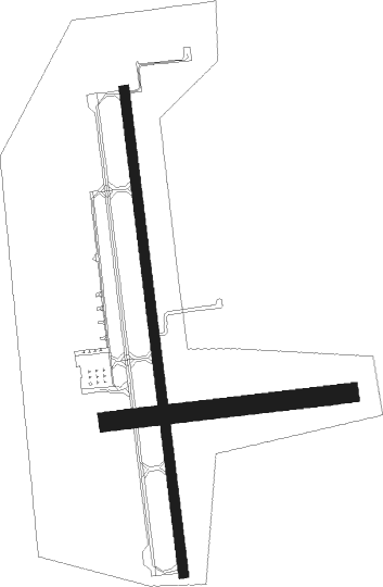
Runway info
Runway 18 / 36  | ||
| length | 1160m (3806ft) | |
| bearing | 177° / 357° | |
| width | 23m (75ft) | |
| surface | asphalt | |
| Runway 09 / 27 | ||
| length | 578m (1896ft) | |
| bearing | 88° / 268° | |
| width | 46m (150ft) | |
| surface | grass | |
| displ threshold | 152m (499ft) / 0m (0ft) | |
Nearby beacons
| code | identifier | dist | bearing | frequency |
|---|---|---|---|---|
| FNT | FLINT VORTAC | 21.7 | 258° | 116.90 |
| PSI | DME | 24.7 | 216° | 111 |
| ECK | PECK TACAN | 26.7 | 71° | 114 |
| PH | PHURN (PORT HURON) NDB | 32.5 | 108° | 332 |
| MTC | SELFRIDGE (MOUNT CLEMENS) TACAN | 33.4 | 136° | 133.70 |
| SVM | SALEM VORTAC | 41.9 | 206° | 114.30 |
| MBS | SAGINAW VOR/DME | 44.9 | 300° | 112.90 |
| MB | OLSTE (SAGINAW) NDB | 46.2 | 294° | 257 |
| QG | WINDSOR NDB | 48.6 | 152° | 353 |
| DM | SPENC (DETROIT) NDB | 50.9 | 175° | 223 |
| DXO | DETROIT VOR/DME | 51.4 | 186° | 113.40 |
| DT | REVUP (DETROIT) NDB | 57.2 | 190° | 388 |
| RYS | GROSSE ILE (DETROIT) NDB | 58.2 | 173° | 419 |
Instrument approach procedures
| runway | airway (heading) | route (dist, bearing) |
|---|---|---|
| RW18 | WIVGU (176°) | WIVGU 3000ft |
| RNAV | WIVGU 3000ft ZIKBI (7mi, 177°) 2400ft YIYUB (3mi, 177°) 1500ft D95 (2mi, 176°) 1180ft (5110mi, 117°) 1180ft ZUSDI (5109mi, 297°) 3000ft ZUSDI (turn) | |
| RW36 | ZUSDI (357°) | ZUSDI 3000ft |
| RNAV | ZUSDI 3000ft WOMDA (7mi, 357°) 2500ft ZOLEP (3mi, 357°) 1660ft D95 (3mi, 357°) 1220ft (5110mi, 117°) 1220ft WIVGU (5112mi, 297°) 3000ft WIVGU (turn) |
Disclaimer
The information on this website is not for real aviation. Use this data with the X-Plane flight simulator only! Data taken with kind consent from X-Plane 12 source code and data files. Content is subject to change without notice.