Lagos - Murtala Muhammed Intl
Airport details
| Country | Nigeria |
| State | Lagos State |
| Region | DN |
| Airspace | Kano Ctr |
| Municipality | Ikeja |
| Elevation | 138ft (42m) |
| Timezone | GMT +1 |
| Coordinates | 6.59356, 3.33489 |
| Magnetic var | |
| Type | land |
| Available since | X-Plane v10.40 |
| ICAO code | DNMM |
| IATA code | LOS |
| FAA code | n/a |
Communication
| Murtala Muhammed Intl ATIS | 123.800 |
| Murtala Muhammed Intl Ground Control | 121.900 |
| Murtala Muhammed Intl Tower | 118.100 |
| Murtala Muhammed Intl Tower | 119.100 |
| Murtala Muhammed Intl Approach | 124.700 |
| Murtala Muhammed Intl Departure | 124.700 |
Approach frequencies
| ILS-cat-II | RW18L | 110.3 | 18.00mi |
| ILS-cat-II | RW18R | 108.1 | 18.00mi |
| 3° GS | RW18L | 110.3 | 18.00mi |
| 3° GS | RW18R | 108.1 | 18.00mi |
Nearby Points of Interest:
Ilojo Bar
-Iga Idunganran
-Sungbo's Eredo
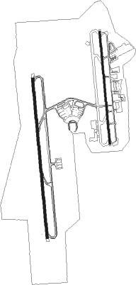
Runway info
Runway 18L / 36R  | ||
| length | 2761m (9058ft) | |
| bearing | 179° / 359° | |
| width | 45m (148ft) | |
| surface | asphalt | |
| Runway 18R / 36L | ||
| length | 3923m (12871ft) | |
| bearing | 179° / 359° | |
| width | 60m (197ft) | |
| surface | asphalt | |
Nearby beacons
| code | identifier | dist | bearing | frequency |
|---|---|---|---|---|
| LA | LAGOS NDB | 0.8 | 334° | 336 |
| LAG | LAGOS VOR/DME | 6.8 | 356° | 113.70 |
| CO | COTONOU NDB | 57.2 | 257° | 284 |
| TYE | COTONOU VOR/DME | 57.8 | 256° | 113.30 |
| IBA | IBADAN VOR/DME | 58.8 | 40° | 112.10 |
| IB | IBADAN NDB | 61.2 | 40° | 400 |
Departure and arrival routes
| Transition altitude | 3500ft |
| Transition level | 5000ft |
| SID end points | distance | outbound heading | |
|---|---|---|---|
| RW18L | |||
| BUDS1S | 72mi | 3° | |
| IBA1S | 59mi | 40° | |
| UMUN2S, UMUN1S | 66mi | 74° | |
| BOTB1S | 62mi | 110° | |
| RW18R | |||
| BUDS1Q | 72mi | 3° | |
| IBA1Q | 59mi | 40° | |
| UMUN1Q | 66mi | 74° | |
| BOTB1Q | 62mi | 110° | |
| PISB1Q | 60mi | 131° | |
| POLT1Q | 35mi | 260° | |
| ILKE1Q | 72mi | 351° | |
| STAR starting points | distance | inbound heading | |
|---|---|---|---|
| RW18L | |||
| BUDS1M | 71.8 | 183° | |
| GUMO1M | 71.4 | 202° | |
| ERSE1M | 68.1 | 236° | |
| EDGO1M | 63.9 | 272° | |
| RW18R | |||
| TYE1N | 57.8 | 76° | |
| ILKE1N | 71.8 | 171° | |
| BUDS1N | 71.8 | 183° | |
| GUMO1N | 71.4 | 202° | |
| ERSE1N | 68.1 | 236° | |
| EDGO1N | 63.9 | 272° | |
| ETVO1N | 59.0 | 329° | |
Instrument approach procedures
| runway | airway (heading) | route (dist, bearing) |
|---|---|---|
| RW18L | OVNIK (194°) | OVNIK 3500ft EDKUV (5mi, 235°) 2810ft |
| RNAV | EDKUV 2810ft MM400 (5mi, 179°) 2000ft DNMM (6mi, 176°) 187ft DNMM (turn) 1000ft MM900 (7mi, 62°) MM901 (8mi, 14°) OVNIK (5mi, 304°) 3500ft OVNIK (turn) 3500ft | |
| RW18R | EBSEX (148°) | EBSEX MOLOP (7mi, 89°) 3500ft |
| RW18R | OVNIK (194°) | OVNIK 3500ft MOLOP (5mi, 269°) 3500ft |
| RNAV | MOLOP 3500ft MM500 (5mi, 179°) 3000ft DNMM (9mi, 171°) 114ft DNMM (turn) 1000ft EBSEX (16mi, 328°) EBSEX (turn) |
Holding patterns
| STAR name | hold at | type | turn | heading* | altitude | leg | speed limit |
|---|---|---|---|---|---|---|---|
| EDGO1M | OVNIK | VHF | left | 56 (236)° | > 3500ft | 1.0min timed | 230 |
| EDGO1N | OVNIK | VHF | left | 56 (236)° | > 3500ft | 1.0min timed | 230 |
| ERSE1M | OVNIK | VHF | left | 56 (236)° | > 3500ft | 1.0min timed | 230 |
| ERSE1N | OVNIK | VHF | left | 56 (236)° | > 3500ft | 1.0min timed | 230 |
| ETVO1N | EBSEX | VHF | left | 271 (91)° | > 5000ft | 1.0min timed | 230 |
| GUMO1M | OVNIK | VHF | left | 56 (236)° | > 3500ft | 1.0min timed | 230 |
| GUMO1N | OVNIK | VHF | left | 56 (236)° | > 3500ft | 1.0min timed | 230 |
| TYE1N | EBSEX | VHF | left | 271 (91)° | > 5000ft | 1.0min timed | 230 |
| *) magnetic outbound (inbound) holding course | |||||||
Disclaimer
The information on this website is not for real aviation. Use this data with the X-Plane flight simulator only! Data taken with kind consent from X-Plane 12 source code and data files. Content is subject to change without notice.