Crane - Crane County
Airport details
| Country | United States of America |
| State | Texas |
| Region | K4 |
| Airspace | Ft Worth Ctr |
| Municipality | Crane County |
| Elevation | 2549ft (777m) |
| Timezone | GMT -6 |
| Coordinates | 31.41514, -102.36292 |
| Magnetic var | |
| Type | land |
| Available since | X-Plane v10.40 |
| ICAO code | E13 |
| IATA code | n/a |
| FAA code | n/a |
Communication
| Crane County CTAF | 122.900 |
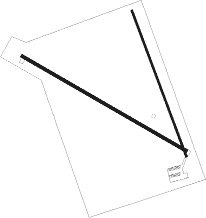
Runway info
Runway 12 / 30  | ||
| length | 1265m (4150ft) | |
| bearing | 120° / 300° | |
| width | 21m (70ft) | |
| surface | asphalt | |
| displ threshold | 0m (0ft) / 116m (381ft) | |
| Runway 15 / 33 | ||
| length | 1036m (3399ft) | |
| bearing | 161° / 341° | |
| width | 15m (50ft) | |
| surface | asphalt | |
| displ threshold | 0m (0ft) / 94m (308ft) | |
Nearby beacons
| code | identifier | dist | bearing | frequency |
|---|---|---|---|---|
| MA | FARLY (MIDLAND) NDB | 34.4 | 4° | 326 |
| MAF | MIDLAND VORTAC | 36.7 | 16° | 114.80 |
| FST | FORT STOCKTON VORTAC | 42 | 233° | 116.90 |
| INK | WINK VORTAC | 52.8 | 298° | 112.10 |
| BGS | BIG SPRING VORTAC | 73.5 | 42° | 117.20 |
Disclaimer
The information on this website is not for real aviation. Use this data with the X-Plane flight simulator only! Data taken with kind consent from X-Plane 12 source code and data files. Content is subject to change without notice.