Alpine Casparis Muni
Airport details
| Country | United States of America |
| State | Texas |
| Region | K4 |
| Airspace | Albuquerque Ctr |
| Municipality | Alpine |
| Elevation | 4515ft (1376m) |
| Timezone | GMT -6 |
| Coordinates | 30.38422, -103.68359 |
| Magnetic var | |
| Type | land |
| Available since | X-Plane v10.30 |
| ICAO code | E38 |
| IATA code | n/a |
| FAA code | n/a |
Communication
| Alpine Casparis Muni AWOS 3 | 119.025 |
| Alpine Casparis Muni CTAF/UNICOM | 122.800 |
| Alpine Casparis Muni ABQ Center | 135.875 |
Nearby Points of Interest:
Presidio County Courthouse
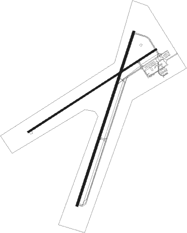
Runway info
Runway 1 / 19  | ||
| length | 1833m (6014ft) | |
| bearing | 26° / 206° | |
| width | 23m (75ft) | |
| surface | asphalt | |
| Runway 5 / 23 | ||
| length | 1528m (5013ft) | |
| bearing | 65° / 245° | |
| width | 18m (60ft) | |
| surface | asphalt | |
Nearby beacons
| code | identifier | dist | bearing | frequency |
|---|---|---|---|---|
| BWR | BREWSTER COUNTY (ALPINE) NDB | 4.8 | 26° | 412 |
| MRF | MARFA VOR/DME | 14.9 | 252° | 115.90 |
| XAA | KENT NDB | 46.4 | 320° | 225 |
| FST | FORT STOCKTON VORTAC | 50 | 51° | 116.90 |
Instrument approach procedures
| runway | airway (heading) | route (dist, bearing) |
|---|---|---|
| RW19 | FST (231°) | FST TIFME (39mi, 239°) 10000ft TIFME (turn) 8000ft |
| RW19 | MRF (72°) | MRF TIFME (25mi, 52°) 10000ft TIFME (turn) 8000ft |
| RNAV | TIFME 8000ft RUWEL (6mi, 206°) 6500ft E38 (7mi, 206°) 4490ft (6112mi, 106°) 5200ft ODKAE (6100mi, 286°) 9000ft ODKAE (turn) 9000ft | |
| RW23 | FST (231°) | FST ODKAE (37mi, 226°) 10000ft ODKAE (turn) 8000ft |
| RW23 | MRF (72°) | MRF ODKAE (29mi, 69°) 10000ft ODKAE (turn) 8000ft |
| RNAV | ODKAE 8000ft JOLKU (7mi, 245°) 6500ft E38 (7mi, 244°) 4488ft (6112mi, 106°) 5400ft ODKAE (6100mi, 286°) 9000ft ODKAE (turn) |
Disclaimer
The information on this website is not for real aviation. Use this data with the X-Plane flight simulator only! Data taken with kind consent from X-Plane 12 source code and data files. Content is subject to change without notice.