Estancia - Estancia Muni
Airport details
| Country | United States of America |
| State | New Mexico |
| Region | |
| Airspace | Albuquerque Ctr |
| Municipality | Estancia |
| Elevation | 6100ft (1859m) |
| Timezone | GMT -7 |
| Coordinates | 34.76456, -106.04266 |
| Magnetic var | |
| Type | land |
| Available since | X-Plane v10.40 |
| ICAO code | E92 |
| IATA code | n/a |
| FAA code | E92 |
Communication
| Estancia Muni CTAF | 122.900 |
Nearby Points of Interest:
Moriarty Eclipse Windmill
-Mountainair Municipal Auditorium
-San Antonito Church and Cemetery
-Gran Quivera Historic District
-Enchanted Mesa Trading Post
-Albuquerque Veterans Administration Medical Center
-El Cerro Tome Site
-Solar Building
-Davis House
-Isleta Pueblo
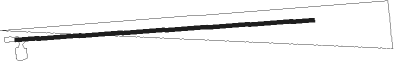
Runway info
| Runway 08 / 26 | ||
| length | 1224m (4016ft) | |
| bearing | 91° / 271° | |
| width | 15m (50ft) | |
| surface | gravel | |
Nearby beacons
| code | identifier | dist | bearing | frequency |
|---|---|---|---|---|
| OTO | OTTO VOR | 19.2 | 19° | 114 |
| CNX | CORONA VORTAC | 29.9 | 137° | 115.50 |
| BRG | DME | 39.6 | 262° | 114.75 |
| ABQ | ALBUQUERQUE VORTAC | 41.6 | 290° | 113.20 |
| AE | DUDLE (ALBUQUERQUE) NDB | 42.7 | 304° | 351 |
| ONM | SOCORRO VORTAC | 46.1 | 241° | 116.80 |
| SAF | SANTA FE VORTAC | 46.6 | 358° | 110.60 |
| FTI | FORT UNION VORTAC | 69.6 | 45° | 117.30 |
Disclaimer
The information on this website is not for real aviation. Use this data with the X-Plane flight simulator only! Data taken with kind consent from X-Plane 12 source code and data files. Content is subject to change without notice.