Mcalister - Akin And Akin
Airport details
| Country | United States of America |
| State | New Mexico |
| Region | |
| Airspace | Albuquerque Ctr |
| Municipality | Quay |
| Elevation | 4856ft (1480m) |
| Timezone | GMT -7 |
| Coordinates | 34.77229, -103.85608 |
| Magnetic var | |
| Type | land |
| Available since | X-Plane v10.30 |
| ICAO code | E99 |
| IATA code | n/a |
| FAA code | NM73 |
Communication
Nearby Points of Interest:
Richardson Store
-Metropolitan Park Bathhouse and Pool Historic District
-Arch Hurley Conservancy District Office Building
-Baca-Goodman House
-Fort Sumner Cemetery Wall and Entry
-Fort Sumner Community House
-Fort Sumner
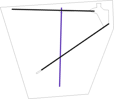
Runway info
| Runway 18 / 36 | ||
| length | 763m (2503ft) | |
| bearing | 187° / 7° | |
| width | 9m (30ft) | |
| surface | grass | |
Runway 05 / 23  | ||
| length | 796m (2612ft) | |
| bearing | 65° / 245° | |
| width | 9m (30ft) | |
| surface | grass | |
| Runway 09 / 27 | ||
| length | 801m (2628ft) | |
| bearing | 95° / 275° | |
| width | 9m (30ft) | |
| surface | grass | |
Nearby beacons
| code | identifier | dist | bearing | frequency |
|---|---|---|---|---|
| TCC | TUCUMCARI VORTAC | 27.6 | 32° | 113.60 |
| CVS | CANNON (CLOVIS) TACAN | 35.3 | 126° | 111.60 |
| CV | HISAN (CLOVIS) NDB | 42.1 | 122° | 335 |
Disclaimer
The information on this website is not for real aviation. Use this data with the X-Plane flight simulator only! Data taken with kind consent from X-Plane 12 source code and data files. Content is subject to change without notice.