Brussels - Brussels National
Airport details
| Country | Belgium |
| State | Flemish Brabant |
| Region | EB |
| Airspace | Brussels Ctr |
| Municipality | Diegem |
| Elevation | 184ft (56m) |
| Timezone | GMT +1 |
| Coordinates | 50.89671, 4.46627 |
| Magnetic var | |
| Type | land |
| Available since | X-Plane v10.40 |
| ICAO code | EBBR |
| IATA code | BRU |
| FAA code | n/a |
Communication
| Brussels National ATIS Departure | 121.750 |
| Brussels National ATIS ARR | 132.475 |
| Brussels National ABELAG UNICOM | 130.550 |
| Brussels National Clearance DEL | 121.950 |
| Brussels National Ground Control | 118.050 |
| Brussels National Ground Control | 121.700 |
| Brussels National Ground Control | 121.875 |
| Brussels National Tower | 118.600 |
| Brussels National Tower | 120.775 |
| Brussels National Approach | 122.500 |
| Brussels National Approach | 118.250 |
| Brussels National Approach | 120.100 |
| Brussels National Departure | 126.625 |
Approach frequencies
| ILS-cat-III | RW25L | 110.35 | 18.00mi |
| ILS-cat-III | RW25R | 108.9 | 18.00mi |
| ILS-cat-I | RW19 | 111.15 | 18.00mi |
| ILS-cat-I | RW01 | 109.9 | 18.00mi |
| 3° GS | RW25L | 110.35 | 18.00mi |
| 3° GS | RW19 | 111.15 | 18.00mi |
| 3° GS | RW25R | 108.9 | 18.00mi |
| 3° GS | RW01 | 109.9 | 18.00mi |
Nearby Points of Interest:
Brussels Airport
-Sint-Martinuskerk
-St. Pancras Church
-Tuchthuis, Vilvoorde
-Kortenberg Abbey
-Gemeentelijk Museum van St. Lambrechts Woluwe
-Maison communale de Woluwe-Saint-Lambert
-Lantern of Lalaing
-Huis Leblicq
-Huis Charles Fortin
-Town hall of Schaerbeek
-Verhaeghe House
-Museum voor de Oudere Technieken | Tommenmolen
-Josaphat School
-Pavillons français
-Kwachethuis
-Maison Van den Heede
-Strauven house
-Domain Lindthout
-Charleroyhoeve
-Royal Military Academy
-Former opthalmological clinic of Doctor Coppez
-embassy of Ethiopia in Belgium
-Former artist studio of the painter Emile Fabry
-Chaussée de Louvain railway station
Runway info
Runway 07L / 25R  | ||
| length | 3641m (11946ft) | |
| bearing | 74° / 254° | |
| width | 45m (148ft) | |
| surface | asphalt | |
| displ threshold | 296m (971ft) / 301m (988ft) | |
| Runway 07R / 25L | ||
| length | 3205m (10515ft) | |
| bearing | 77° / 257° | |
| width | 45m (148ft) | |
| surface | asphalt | |
| displ threshold | 125m (410ft) / 0m (0ft) | |
| Runway 01 / 19 | ||
| length | 2990m (9810ft) | |
| bearing | 22° / 202° | |
| width | 50m (164ft) | |
| surface | asphalt | |
| displ threshold | 46m (151ft) / 229m (751ft) | |
Airport layout
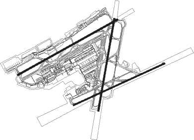
Taxiway locations
|
Parking locations
|
Nearby beacons
| code | identifier | dist | bearing | frequency |
|---|---|---|---|---|
| BUB | BRUSSELS VOR/DME | 2.7 | 86° | 114.60 |
| OZ | BRUSSELS NATIONAL NDB | 4.2 | 179° | 314 |
| OP | BRUSSELS NATIONAL NDB | 5.4 | 72° | 402 |
| OB | BRUSSELS NDB | 5.8 | 81° | 293 |
| HUL | HULDENBERG VOR/DME | 11 | 130° | 117.55 |
| AFI | AFFLIGEM VOR/DME | 12.4 | 272° | 114.90 |
| BBE | BEAUVECHAIN TACAN | 14.2 | 115° | 116 |
| HTB | BEAUVECHAIN NDB | 14.2 | 115° | 381 |
| ONW | ANTWERP NDB | 16.6 | 20° | 355 |
| ANT | ANTWERP (DEURNE) VOR/DME | 17.6 | 1° | 113.50 |
| NIK | NICKY VOR/DME | 19.3 | 314° | 117.40 |
| BUN | BRUNO VOR/DME | 19.4 | 59° | 110.60 |
| ONC | CHARLEROI NDB | 24.6 | 168° | 323 |
| FLO | FLORA VOR/DME | 25.3 | 92° | 112.05 |
| GSY | GOSLY (CHARLEROI) VOR/DME | 26.6 | 183° | 115.70 |
| CIV | CHIEVRES VORTAC | 30.9 | 243° | 113.20 |
| WDT | WOENSDRECHT TACAN | 33.3 | 347° | 115 |
| MAK | MACKEL NDB | 36.9 | 274° | 360 |
| BFS | FLORENNES TACAN | 39.9 | 164° | 111.50 |
| BBL | KLEINE BROGEL TACAN | 41 | 75° | 109.60 |
| GZR | GILZE-RIJEN TACAN | 43.8 | 35° | 116.40 |
| EHV | EINDHOVEN TACAN | 47.6 | 59° | 117.20 |
Departure and arrival routes
| Transition altitude | 4500ft |
| Transition level | 50ft |
| SID end points | distance | outbound heading | |
|---|---|---|---|
| RW01 | |||
| ELSI2F | 27mi | 61° | |
| LNO7F | 51mi | 104° | |
| SPI7F | 50mi | 108° | |
| SOPO7F | 63mi | 116° | |
| PITE7F | 105mi | 120° | |
| ROUS7F | 106mi | 131° | |
| KOK2F | 70mi | 276° | |
| DENU8F | 37mi | 293° | |
| HELE8F | 30mi | 300° | |
| NIK5F | 19mi | 314° | |
| RW07L | |||
| ELSI1H | 27mi | 61° | |
| LNO2T, LNO2W, LNO6H | 51mi | 104° | |
| SPI7H, SPI2W, SPI2T | 50mi | 108° | |
| SOPO6H, SOPO2W, SOPO2T | 63mi | 116° | |
| PITE8H, PITE2W | 105mi | 120° | |
| ROUS2W, ROUS8H | 106mi | 131° | |
| KOK1H | 70mi | 276° | |
| DENU4H | 37mi | 293° | |
| HELE4H | 30mi | 300° | |
| NIK1H | 19mi | 314° | |
| RW07R | |||
| ELSI2J | 27mi | 61° | |
| LNO6J, LNO2Y, LNO2V | 51mi | 104° | |
| SPI2V, SPI2Y, SPI6J | 50mi | 108° | |
| SOPO6J, SOPO2Y, SOPO2V | 63mi | 116° | |
| PITE2Y, PITE8J | 105mi | 120° | |
| ROUS8J, ROUS2Y | 106mi | 131° | |
| KOK2J | 70mi | 276° | |
| DENU2J | 37mi | 293° | |
| HELE2J | 30mi | 300° | |
| NIK2J | 19mi | 314° | |
| RW19 | |||
| ELSI2L | 27mi | 61° | |
| LNO7L | 51mi | 104° | |
| SPI6L | 50mi | 108° | |
| SOPO7L | 63mi | 116° | |
| PITE8L | 105mi | 120° | |
| ROUS8L | 106mi | 131° | |
| KOK8L | 70mi | 276° | |
| DENU7N, DENU8L | 37mi | 293° | |
| HELE6N, HELE6L | 30mi | 300° | |
| NIK5N, NIK3L | 19mi | 314° | |
| RW25L | |||
| ELSI4C, ELSI4D | 27mi | 61° | |
| LNO6Q, LNO4D, LNO2K, LNO2E | 51mi | 104° | |
| SPI2K, SPI4D, SPI6Q, SPI2E | 50mi | 108° | |
| SOPO2K, SOPO5D, SOPO9C, SOPO2G | 63mi | 116° | |
| PITE8C, PITE2K, PITE2G, PITE5D | 105mi | 120° | |
| ROUS8C, ROUS5D, ROUS2K, ROUS2G | 106mi | 131° | |
| KOK5C | 70mi | 276° | |
| DENU7C | 37mi | 293° | |
| HELE7C | 30mi | 300° | |
| NIK4C | 19mi | 314° | |
| RW25R | |||
| ELSI4C, ELSI4D | 27mi | 61° | |
| LNO6C, LNO4D, LNO2M, LNO2K, LNO2G, LNO6Z | 51mi | 104° | |
| SPI7Z, SPI2G, SPI2K, SPI2M, SPI4D, SPI6C | 50mi | 108° | |
| SOPO2K, SOPO2G, SOPO9C, SOPO7Z, SOPO2M, SOPO5D | 63mi | 116° | |
| PITE7Z, PITE5D, PITE2K, PITE2G, PITE8C | 105mi | 120° | |
| ROUS5D, ROUS8C, ROUS6Z, ROUS2K, ROUS2G | 106mi | 131° | |
| KOK5C | 70mi | 276° | |
| DENU7C | 37mi | 293° | |
| HELE7C | 30mi | 300° | |
| NIK4C | 19mi | 314° | |
| STAR starting points | distance | inbound heading | |
|---|---|---|---|
| ALL | |||
| ARVO7A, ARVO7B | 42.4 | 70° | |
| TULN7B, TULN7A | 49.4 | 74° | |
| KOK7A | 69.5 | 96° | |
| WODY7A, WODY3B | 30.7 | 169° | |
| BEKE7A, BEKE3B | 32.4 | 192° | |
| BATY5A | 54.5 | 280° | |
| LNO4A | 50.8 | 284° | |
Instrument approach procedures
| runway | airway (heading) | route (dist, bearing) |
|---|---|---|
| RW01 | ANT (181°) | ANT AFI (21mi, 230°) RUDEL (14mi, 159°) 2200ft NIVOR (3mi, 81°) BURUS (5mi, 81°) 2000ft |
| RW01 | FLO (272°) | FLO BUB (23mi, 272°) AFI (15mi, 271°) RUDEL (14mi, 159°) 2200ft NIVOR (3mi, 81°) BURUS (5mi, 81°) 2000ft |
| RW01 | KERKY (94°) | KERKY AFI (6mi, 98°) RUDEL (14mi, 159°) 2200ft NIVOR (3mi, 81°) BURUS (5mi, 81°) 2000ft |
| RNAV | BURUS 2000ft BR01F (5mi, 22°) 2000ft EBBR (6mi, 7°) 227ft (3065mi, 185°) 1500ft (turn) 4000ft | |
| RW19 | ANT (181°) | ANT LEBVU (18mi, 207°) BUB (8mi, 91°) UMPES (13mi, 54°) INRAB (4mi, 297°) VAMVO (4mi, 279°) 3000ft |
| RW19 | BUN (239°) | BUN 3000ft VAMVO (10mi, 270°) 3000ft |
| RW19 | FLO (272°) | FLO UMPES (18mi, 297°) INRAB (4mi, 297°) VAMVO (4mi, 279°) 3000ft |
| RW19 | KERKY (94°) | KERKY 4000ft AFI (6mi, 98°) LEBVU (7mi, 91°) BUB (8mi, 91°) UMPES (13mi, 54°) INRAB (4mi, 297°) VAMVO (4mi, 279°) 3000ft |
| RNAV | VAMVO 3000ft BR19F (4mi, 202°) 3000ft EBBR (10mi, 211°) 159ft (3065mi, 185°) 1100ft (turn) 3000ft | |
| RW25L | ANT (181°) | ANT BUN (15mi, 101°) NAXOD (6mi, 167°) GIKNU (4mi, 233°) 2000ft |
| RW25L | FLO (272°) | FLO DIKBO (12mi, 292°) 3000ft GIKNU (3mi, 257°) 2000ft |
| RW25L | KERKY (94°) | KERKY 4000ft OKLUP (29mi, 77°) BUN (5mi, 78°) NAXOD (6mi, 167°) GIKNU (4mi, 233°) 2000ft |
| RNAV | GIKNU 2000ft B25LF (5mi, 257°) 2000ft EBBR (8mi, 260°) 209ft (3065mi, 185°) 700ft (turn) 4000ft | |
| RW25R | ANT (181°) | ANT BUN (15mi, 101°) NAXOD (6mi, 167°) UVETI (4mi, 254°) 2000ft |
| RW25R | FLO (272°) | FLO DIKBO (12mi, 292°) 3000ft UVETI (4mi, 273°) 2000ft |
| RW25R | KERKY (94°) | KERKY 4000ft OKLUP (29mi, 77°) BUN (5mi, 78°) NAXOD (6mi, 167°) UVETI (4mi, 254°) 2000ft |
| RNAV | UVETI 2000ft B25RF (5mi, 254°) 2000ft EBBR (7mi, 252°) 156ft (3065mi, 185°) 700ft (turn) 3000ft |
Holding patterns
| STAR name | hold at | type | turn | heading* | altitude | leg | speed limit |
|---|---|---|---|---|---|---|---|
| ARVO7A | KERKY | VHF | right | 280 (100)° | 4000ft - 9000ft | 1.0min timed | ICAO rules |
| ARVO7B | FLO | NDB | right | 128 (308)° | 6000ft - 14000ft | 1.0min timed | ICAO rules |
| BATY5A | FLO | NDB | right | 128 (308)° | 6000ft - 14000ft | 1.0min timed | ICAO rules |
| BEKE3B | KERKY | VHF | right | 280 (100)° | 4000ft - 9000ft | 1.0min timed | ICAO rules |
| BEKE7A | ANT | NDB | left | 297 (117)° | 8000ft - 14000ft | 1.0min timed | ICAO rules |
| KOK7A | KERKY | VHF | right | 280 (100)° | 4000ft - 9000ft | 1.0min timed | ICAO rules |
| LNO4A | FLO | NDB | right | 128 (308)° | 6000ft - 14000ft | 1.0min timed | ICAO rules |
| TULN7A | KERKY | VHF | right | 280 (100)° | 4000ft - 9000ft | 1.0min timed | ICAO rules |
| TULN7B | FLO | NDB | right | 128 (308)° | 6000ft - 14000ft | 1.0min timed | ICAO rules |
| WODY3B | KERKY | VHF | right | 280 (100)° | 4000ft - 9000ft | 1.0min timed | ICAO rules |
| WODY7A | ANT | NDB | left | 297 (117)° | 8000ft - 14000ft | 1.0min timed | ICAO rules |
| *) magnetic outbound (inbound) holding course | |||||||
Disclaimer
The information on this website is not for real aviation. Use this data with the X-Plane flight simulator only! Data taken with kind consent from X-Plane 12 source code and data files. Content is subject to change without notice.