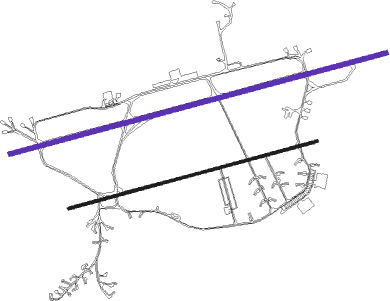
Florennes
Airport details
| Country | Belgium |
| State | Namur |
| Region | EB |
| Airspace | Brussels Ctr |
| Municipality | Florennes |
| Elevation | 899ft (274m) |
| Timezone | GMT +1 |
| Coordinates | 50.24333, 4.64583 |
| Magnetic var | |
| Type | land |
| Available since | X-Plane v10.40 |
| ICAO code | EBFS |
| IATA code | n/a |
| FAA code | n/a |
Communication
| Florennes Ground Control | 122.100 |
| Florennes Tower | 122.100 |
| Florennes Approach | 122.500 |
| Florennes GCA | 123.300 |
Approach frequencies
| ILS-cat-I | RW26R | 108.35 | 18.00mi |
| ILS-cat-I | RW08L | 108.35 | 18.00mi |
| 3° GS | RW08L | 108.35 | 18.00mi |
| 2.7° GS | RW26R | 108.35 | 18.00mi |
Nearby Points of Interest:
Roly
-Cellatex
-Couvent des Récollectines de Givet
-Manège militaire de Givet
-Rochers de Freÿr
-Maison Gambier
-Château Pirmez
-Amicale Solvay
-Montignies-sur-Sambre - Chapelle du Calvaire
-Farciennes Castle
-Aiguilles de Chaleux
-Cité de l'Enfance
-Brewery-mill of the Floreffe Abbey
-Résidence Albert
-Maison Dermine
-Immeuble De Heug
-Hôtel des Postes
-Passage de la Bourse (Charleroi)
-Maison Dorée (Charleroi)
-Maison du Bailli
-Charleroi City Hall
-Maison des médecins
-Maison La Fleur (Charleroi)
-Maison Bertinchamps (Charleroi)
-Île de Dave
Runway info
Nearby beacons
| code | identifier | dist | bearing | frequency |
|---|---|---|---|---|
| BFS | FLORENNES TACAN | 0.3 | 104° | 111.50 |
| GSY | GOSLY (CHARLEROI) VOR/DME | 14.8 | 316° | 115.70 |
| ONC | CHARLEROI NDB | 15.1 | 340° | 323 |
| HUL | HULDENBERG VOR/DME | 30.3 | 360° | 117.55 |
| BBE | BEAUVECHAIN TACAN | 31.1 | 13° | 116 |
| HTB | BEAUVECHAIN NDB | 31.1 | 13° | 381 |
| OZ | BRUSSELS NATIONAL NDB | 35.6 | 343° | 314 |
| CIV | CHIEVRES VORTAC | 36.9 | 292° | 113.20 |
| BUB | BRUSSELS VOR/DME | 39.7 | 351° | 114.60 |
| LGE | LIEGE VOR/DME | 40 | 64° | 115.45 |
| OB | BRUSSELS NDB | 40.6 | 357° | 293 |
| SPI | SPRIMONT VOR/DME | 40.8 | 74° | 113.10 |
| OP | BRUSSELS NATIONAL NDB | 41.8 | 356° | 402 |
| FLO | FLORA VOR/DME | 42.3 | 38° | 112.05 |
| ONL | LIEGE NDB | 44.1 | 63° | 290 |
| AFI | AFFLIGEM VOR/DME | 44.3 | 323° | 114.90 |
| BUN | BRUNO VOR/DME | 53 | 13° | 110.60 |
| MMD | MONTMEDY VOR | 54.4 | 151° | 109.40 |
| ONW | ANTWERP NDB | 55.5 | 355° | 355 |
| ANT | ANTWERP (DEURNE) VOR/DME | 57.2 | 350° | 113.50 |
| NIK | NICKY VOR/DME | 58 | 333° | 117.40 |
| REM | REIMS VOR | 60.6 | 213° | 112.30 |
| BBL | KLEINE BROGEL TACAN | 63.6 | 42° | 109.60 |
Departure and arrival routes
| Transition altitude | 4500ft |
| SID end points | distance | outbound heading | |
|---|---|---|---|
| RW08L | |||
| FS08B | 20mi | 118° | |
| RW26R | |||
| FS26B | 20mi | 118° | |
Instrument approach procedures
| runway | airway (heading) | route (dist, bearing) |
|---|---|---|
| RW08L | FS500 (11°) | FS500 FS501 (9mi, 263°) FS502 (5mi, 344°) 3000ft |
| RW08L | FS510 (83°) | FS510 FS502 (6mi, 83°) 3000ft |
| RW08L | FS520 (100°) | FS520 FS502 (5mi, 164°) 3000ft |
| RNAV | FS502 3000ft FS507 (5mi, 83°) 2500ft FS504 (5mi, 83°) 955ft FS505 (6mi, 83°) 2260ft FS506 (5mi, 164°) 3000ft FS500 (7mi, 264°) 3000ft FS500 (turn) 4500ft | |
| RW26R | FS400 (319°) | FS400 FS401 (9mi, 83°) FS402 (5mi, 344°) 3000ft |
| RW26R | FS410 (263°) | FS410 FS402 (6mi, 263°) 3000ft |
| RW26R | FS420 (246°) | FS420 FS402 (5mi, 175°) 3000ft |
| RNAV | FS402 3000ft FS403 (5mi, 263°) 2500ft FS404 (5mi, 263°) 978ft FS405 (6mi, 263°) 1980ft FS406 (5mi, 164°) 2820ft FS400 (7mi, 82°) 3000ft FS400 (turn) 4500ft |
Disclaimer
The information on this website is not for real aviation. Use this data with the X-Plane flight simulator only! Data taken with kind consent from X-Plane 12 source code and data files. Content is subject to change without notice.

