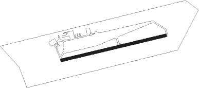
Leopoldsburg - Sanicole
Airport details
| Country | Belgium |
| State | Limburg |
| Region | EB |
| Airspace | Brussels Ctr |
| Municipality | Hechtel-Eksel |
| Elevation | 207ft (63m) |
| Timezone | GMT +1 |
| Coordinates | 51.12000, 5.30722 |
| Magnetic var | |
| Type | land |
| Available since | X-Plane v10.40 |
| ICAO code | EBLE |
| IATA code | n/a |
| FAA code | n/a |
Communication
| Sanicole ATC Freq | 125.530 |
Nearby Points of Interest:
Heilig Sacramentskerk
-voormalig stadhuis van Peer
-Sint-Barbarakerk
-Sint-Pauluskerk
-Maagd der Armenkerk
-Bookmolen
-Vrankenschans
-Korenmolen
-De Holsteen
-Heilige Kruiskapel (Luyksgestel)
-Gelatinefabriek
-Michielshuis
-Sint-Michielscollege
-Grauwzustersklooster
-De Abraham
-Huis Van Straelen
-Kolonel Dusartplein
-Beguinage of Hasselt
-Het Zonneke
-De Brabantsche Huyck
-voormalig Provincieraadsgebouw
-Town Hall, Hasselt
-De Roode Poort
-Het Lombardenhuys
-Huis Cornu
Nearby beacons
| code | identifier | dist | bearing | frequency |
|---|---|---|---|---|
| BBL | KLEINE BROGEL TACAN | 6.5 | 73° | 109.60 |
| FLO | FLORA VOR/DME | 16 | 215° | 112.05 |
| BUN | BRUNO VOR/DME | 17.5 | 270° | 110.60 |
| EHV | EINDHOVEN TACAN | 19.8 | 12° | 117.20 |
| NW | MAASTRICHT NDB | 22.3 | 100° | 373 |
| MAS | MAASTRICHT VOR/DME | 26.2 | 103° | 108.60 |
| ONL | LIEGE NDB | 26.7 | 150° | 290 |
| ONW | ANTWERP NDB | 28 | 274° | 355 |
| LGE | LIEGE VOR/DME | 28.6 | 161° | 115.45 |
| OB | BRUSSELS NDB | 28.7 | 254° | 293 |
| OP | BRUSSELS NATIONAL NDB | 29.1 | 256° | 402 |
| GIX | GEILENKIRCHEN TACAN | 29.4 | 102° | 108.10 |
| BBE | BEAUVECHAIN TACAN | 29.8 | 236° | 116 |
| HTB | BEAUVECHAIN NDB | 29.9 | 236° | 381 |
| GZR | GILZE-RIJEN TACAN | 30.2 | 320° | 116.40 |
| ANT | ANTWERP (DEURNE) VOR/DME | 31.7 | 275° | 113.50 |
| BUB | BRUSSELS VOR/DME | 31.8 | 254° | 114.60 |
| HUL | HULDENBERG VOR/DME | 33.6 | 241° | 117.55 |
| VKL | VOLKEL TACAN | 35.4 | 37° | 108.30 |
| LNO | OLNO VOR/DME | 35.5 | 143° | 112.80 |
| OZ | BRUSSELS NATIONAL NDB | 36.3 | 251° | 314 |
| SPI | SPRIMONT VOR/DME | 38.2 | 152° | 113.10 |
| WDT | WOENSDRECHT TACAN | 41.1 | 289° | 115 |
| NID | DME | 42.5 | 60° | 115.50 |
| LAA | NIEDERRHEIN NDB | 43.4 | 61° | 352 |
| SLV | SPA NDB | 44.8 | 137° | 386 |
| ONC | CHARLEROI NDB | 47.4 | 230° | 323 |
| GSY | GOSLY (CHARLEROI) VOR/DME | 51.7 | 232° | 115.70 |
| FRT | DME | 56.7 | 329° | 117.15 |
| BFS | FLORENNES TACAN | 58.3 | 217° | 111.50 |
| RTM | ROTTERDAM VOR/DME | 59.8 | 316° | 110.40 |
| DLN | DEELEN TACAN | 60.1 | 31° | 112.20 |
Disclaimer
The information on this website is not for real aviation. Use this data with the X-Plane flight simulator only! Data taken with kind consent from X-Plane 12 source code and data files. Content is subject to change without notice.
