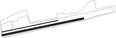
Airports for X-Plane offers a convenient way to explore airports and their related communication information for the X-Plane flight simulator. It only uses data from the X-Plane flight simulator itself, and is therefore more reliable than the data that comes from real aviation websites. You can search for airports by using the ICAO code, or browse for airports per country and state. The information displayed is categorized by airport details, runway information, airport communication, approach frequencies (ILS and Glidepath details), details of nearby beacons, SIDs, STARs and approach procedures.

aircraft airbase takeoff immigration seaplane air terminal aerodromes helicopters road airbus airborne non-towered airport train airfield traffic pattern rail transport airplane asphalt airport terminal newark southwest

Fuessen

Airport details

CountryGermany
StateBavaria
Region
AirspaceMunich Ctr
MunicipalityFüssen
Elevation2583ft (787m)
TimezoneGMT +1
Coordinates47.58271, 10.68760
Magnetic var
Typeland
Available sinceX-Plane v10.40
ICAO codeED02
IATA coden/a
FAA coden/a

Communication

Fuessen Fuessen Info118.935
Nearby Points of Interest:
Brotmarkt 8 (Füssen)
-
Burgstall Frauenstein
-
St. Nikolaus (Oberkirch, Füssen)
-
Schloss Hopferau
-
Römersiedlung Tegelberg
-
Stadtpfarrkirche Mariae Himmelfahrt, Vils
-
Museum Vils
-
Vorwerke der Burg Ehrenberg
-
Pfarrkirche Lechaschau
-
Pfarrkirche Wängle
-
Reutte Friary
-
Dekanatspfarrkirche hll. Petrus und Paulus, Breitenwang
-
Burgstall Falkensberg
-
Katholische Kapelle Mariae Opferung
-
Kapelle St. Wendelin (Lechbruck am See)
-
Pfarrkirche Grän
-
Haus Hauptstraße 25 (Nesselwang)
-
Pfarrkirche Mariä Himmelfahrt, Heiterwang
-
Saint John of Nepomuk Chapel (Günther, Bernbeuren)
-
Pfarrkirche Unsere Liebe Frau Mariae Namen, Jungholz
-
Ensemble Ortskern Bernbeuren
-
Auerbergmuseum im Kiebelehaus
-
Steingaden Abbey
-
Pfarrkirche hl. Jakobus d. Ä., Berwang
-
Maria Patrona Bavariä

Runway info

Runway 08 / 26  
 length522m (1713ft)
 bearing85° / 265°
 width6m (18ft)
 surfaceasphalt
Runway 08R / 26L  
 length752m (2467ft)
 bearing85° / 265°
 width16m (52ft)
 surfacegrass
 displ threshold0m (0ft) / 224m (735ft)

Airport layout


Parking locations

Nearby beacons

codeidentifierdistbearingfrequency
KPTKEMPTEN VOR/DME16.8296°108.40
ALGALLGAEU (MEMMINGEN) NDB30.2314°341
ALD(MEMMINGEN/ALLGAU) DME30.5312°117.20
INNINNSBRUCK NDB35.9116°420
RUMRUM NDB36.5112°320
LCHLECHFELD TACAN37.116°108.80
OBIOBERPFAFFENHOFEN NDB38.450°429
PATDME38.6116°112
MAHMAISACH VOR/DME47.943°115.20
LUPLAUPHEIM NDB49.3309°407
AGBAUGSBURG NDB51.416°318
AUGDME51.517°115.90
WFJDME57.8230°113.75
MSEMUNICH NDB59.452°358
MNEMUNICH NDB6152°369
WLDWALDA VOR/DME62.424°112.80
MIQMIKE NDB69.643°426

Disclaimer

The information on this website is not for real aviation. Use this data with the X-Plane flight simulator only! Data taken with kind consent from X-Plane 12 source code and data files. Content is subject to change without notice.