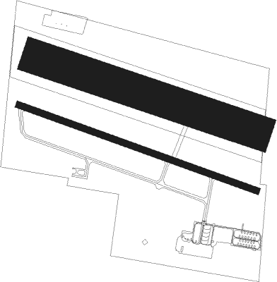
Airports for X-Plane offers a convenient way to explore airports and their related communication information for the X-Plane flight simulator. It only uses data from the X-Plane flight simulator itself, and is therefore more reliable than the data that comes from real aviation websites. You can search for airports by using the ICAO code, or browse for airports per country and state. The information displayed is categorized by airport details, runway information, airport communication, approach frequencies (ILS and Glidepath details), details of nearby beacons, SIDs, STARs and approach procedures.

bus concrete airfield traffic pattern airports stopover air traffic control military passengers flights landing airbus air safety embassy airport apron downtown aerodrome frankfurt airport port hotel near

Oppin - Halle-oppin

Airport details

CountryGermany
StateSaxony-Anhalt
RegionED
AirspaceMunich Ctr
MunicipalityLandsberg
Elevation350ft (107m)
TimezoneGMT +1
Coordinates51.54951, 12.05799
Magnetic var
Typeland
Available sinceX-Plane v10.40
ICAO codeEDAQ
IATA coden/a
FAA coden/a

Communication

Halle-Oppin Oppin Info135.150
Nearby Points of Interest:
Windmühle Plößnitz
-
Harsdorfer Platz 10
-
Ethel-Rosenberg-Straße
-
St. Michael (Brachstedt)
-
Dorfstraße 10
-
Dorfstraße 7, 8, 10-12
-
Dorfstraße 7
-
Aus dem Leben Friedrich Engels
-
Halle-Trotha station
-
Solbad Wittekind
-
Dorfkirche Merkewitz
-
Straßenbahnmuseum Halle
-
Mohrenapotheke
-
Stephanuskirche (Halle)
-
Kloster Petersberg
-
Distanzstein
-
Villa Heine
-
Villa Kaehne
-
Stadtgymnasium Halle
-
Goetheplatz 10 (Dölbau)
-
Herrenhaus Mößlitz
-
Villa Lehmann (Halle)
-
Kriegerdenkmal Werderthau
-
Church Wallwitz
-
Wilhelm-Pieck-Platz 7

Runway info

Runway 11 / 29  
 length1118m (3668ft)
 bearing106° / 286°
 width30m (98ft)
 surfaceasphalt
 displ threshold60m (197ft) / 60m (197ft)
Runway 11L / 29R  
 length1008m (3307ft)
 bearing105° / 285°
 width150m (492ft)
 surfacegrass

Airport layout


Taxiway locations
Parking locations

Nearby beacons

codeidentifierdistbearingfrequency
LNDNORTH(LEIPZIG- DME9.3124°113.50
LLDSOUTH(LEIPZIG- DME10.3128°112.15
ZIGLEIPZIG NDB10.8117°340
SKZSCHKEUDITZ (LEIPZIG-HALLE) NDB11.3122°357
LEGLEIPZIG VOR/DME16.9105°115.85
GOTGOTEM VOR/DME21.2246°115.25
MAGMAGDEBURG VOR/DME28.4329°110.45
CBCOCHSTEDT NDB29.3297°344
ABUALTENBURG NDB37.6140°330
AGDDME38141°115.30
ERFERFURT VOR/DME47.3234°113.85

Disclaimer

The information on this website is not for real aviation. Use this data with the X-Plane flight simulator only! Data taken with kind consent from X-Plane 12 source code and data files. Content is subject to change without notice.