Roitzschjora
Airport details
| Country | Germany |
| State | Saxony |
| Region | ED |
| Airspace | Munich Ctr |
| Municipality | Löbnitz |
| Elevation | 289ft (88m) |
| Timezone | GMT +1 |
| Coordinates | 51.57784, 12.49433 |
| Magnetic var | |
| Type | land |
| Available since | X-Plane v10.40 |
| ICAO code | EDAW |
| IATA code | n/a |
| FAA code | n/a |
Communication
| Roitzschjora Roitzschjora Info | 122.350 |
Nearby Points of Interest:
Dorfkirche Löbnitz
-Pegelhaus (Bad Düben)
-Burgschänke Goldener Löwe
-Blücherdenkmal (Bad Düben)
-St. Lukas
-Kriegerdenkmal Gossa
-Lutherhaus
-Pfarrkirche Herz Jesu
-Binnengärtenstraße 10
-St. Franziskushaus
-Röhrenstraße 8
-Röhrenstraße 11, Saarstraße 1a
-Binnengärtenstraße 6, 7
-Bahnkraftwerk Muldenstein
-Erbrichtergut
-Gustav-Kögel-Denkmal
-Francis Xavier Church (Eilenburg)
-Stadtfriedhof Eilenburg
-Eilenburger Chemiewerk
-Röberstift
-Bunker Kossa
-Kaiser-Wilhelm-Tower
-Schloss Gräfenhainichen
-Kirche Hohenheida
-Gebäude 041
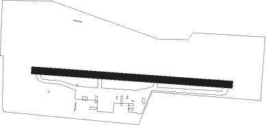
Runway info
| Runway 10 / 28 | ||
| length | 1150m (3773ft) | |
| bearing | 95° / 275° | |
| width | 40m (131ft) | |
| surface | grass | |
| blast zone | 0m (0ft) / 52m (171ft) | |
Nearby beacons
| code | identifier | dist | bearing | frequency |
|---|---|---|---|---|
| LEG | LEIPZIG VOR/DME | 8.5 | 188° | 115.85 |
| ZIG | LEIPZIG NDB | 11.7 | 236° | 340 |
| SKZ | SCHKEUDITZ (LEIPZIG-HALLE) NDB | 12.8 | 234° | 357 |
| LND | NORTH(LEIPZIG- DME | 13.2 | 242° | 113.50 |
| LLD | SOUTH(LEIPZIG- DME | 13.8 | 238° | 112.15 |
| HOZ | HOLZDORF NDB | 25.2 | 72° | 406 |
| HOZ | HOLZDORF TACAN | 28.5 | 75° | 117.25 |
| ABU | ALTENBURG NDB | 35 | 177° | 330 |
| AGD | DME | 35.7 | 178° | 115.30 |
| MAG | MAGDEBURG VOR/DME | 36.1 | 301° | 110.45 |
| GOT | GOTEM VOR/DME | 36.3 | 255° | 115.25 |
| BBI | BERLIN BRANDENBURG VOR/DME | 58 | 51° | 114.10 |
Disclaimer
The information on this website is not for real aviation. Use this data with the X-Plane flight simulator only! Data taken with kind consent from X-Plane 12 source code and data files. Content is subject to change without notice.