Jena - Jena-schöngleina
Airport details
| Country | Germany |
| State | Thuringia |
| Region | ED |
| Airspace | Munich Ctr |
| Municipality | Schöngleina |
| Elevation | 1228ft (374m) |
| Timezone | GMT +1 |
| Coordinates | 50.91364, 11.71526 |
| Magnetic var | |
| Type | land |
| Available since | X-Plane v10.40 |
| ICAO code | EDBJ |
| IATA code | n/a |
| FAA code | n/a |
Communication
| Jena-Schöngleina Jena Info | 122.050 |
Nearby Points of Interest:
Dorfkirche Mennewitz
-Schloss Stadtroda
-Schloss Drackendorf
-Hummelstedt
-Burgruine Burgau
-Capitol
-Kulturbahnhof Jena
-Jena Observatory
-Zeiss Building 15
-Ernst-Haeckel-Haus
-F-Haus
-Papierlager Gustav-Fischer-Verlag Jena
-Max Planck Institute for the Science of Human History
-Schaefferstraße 9 (Jena)
-St. Nicholas church
-Kirche Hainichen
-Ammerbach church
-Dorfkirche Cospeda
-Dorfkirche Krippendorf
-Protestant Church (Großpürschütz)
-Wasserburg Isserstedt
-Kirche
-Dorfkirche Kleinromstedt
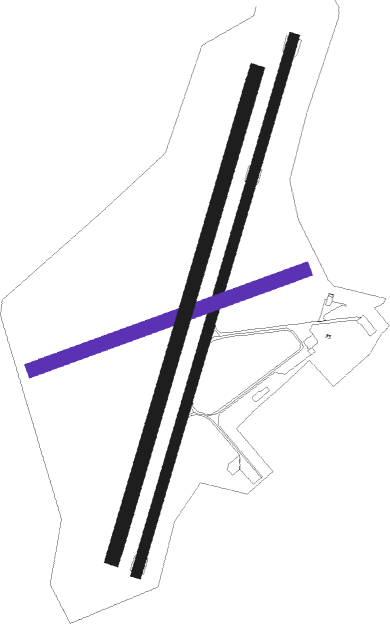
Runway info
Runway 02 / 20  | ||
| length | 1201m (3940ft) | |
| bearing | 31° / 211° | |
| width | 23m (75ft) | |
| surface | asphalt | |
| displ threshold | 30m (98ft) / 0m (0ft) | |
| Runway 08 / 26 | ||
| length | 621m (2037ft) | |
| bearing | 80° / 260° | |
| width | 30m (98ft) | |
| surface | grass | |
| Runway 02L / 20R | ||
| length | 1093m (3586ft) | |
| bearing | 31° / 211° | |
| width | 30m (98ft) | |
| surface | grass | |
Nearby beacons
| code | identifier | dist | bearing | frequency |
|---|---|---|---|---|
| ERF | ERFURT VOR/DME | 18.2 | 274° | 113.85 |
| GOT | GOTEM VOR/DME | 26.1 | 345° | 115.25 |
| EFD | DME | 28.9 | 275° | 112.05 |
| AGD | DME | 30.4 | 85° | 115.30 |
| ABU | ALTENBURG NDB | 30.8 | 84° | 330 |
| LLD | SOUTH(LEIPZIG- DME | 35.8 | 46° | 112.15 |
| SKZ | SCHKEUDITZ (LEIPZIG-HALLE) NDB | 36.6 | 48° | 357 |
| LND | NORTH(LEIPZIG- DME | 36.7 | 44° | 113.50 |
| ZIG | LEIPZIG NDB | 37.8 | 47° | 340 |
| LEG | LEIPZIG VOR/DME | 42.4 | 55° | 115.85 |
| BAY | BAYREUTH VOR | 55.8 | 185° | 110.60 |
| OKG | CHEB VOR/DME | 57.3 | 141° | 115.70 |
| CB | COCHSTEDT NDB | 57.7 | 344° | 344 |
Disclaimer
The information on this website is not for real aviation. Use this data with the X-Plane flight simulator only! Data taken with kind consent from X-Plane 12 source code and data files. Content is subject to change without notice.