Airports for X-Plane offers a convenient way to explore airports and their related communication information for the X-Plane flight simulator. It only uses data from the X-Plane flight simulator itself, and is therefore more reliable than the data that comes from real aviation websites. You can search for airports by using the ICAO code, or browse for airports per country and state. The information displayed is categorized by airport details, runway information, airport communication, approach frequencies (ILS and Glidepath details), details of nearby beacons, SIDs, STARs and approach procedures.

non-towered airport grass plane airbus metro airspace transit rail transport bus arriving landing area air traffic control airport terminal gravel stol flown taxi helicopters runway lighting road

Bronkow

Airport details

CountryGermany
StateBrandenburg
RegionED
AirspaceBremen Ctr
MunicipalityLuckaitztal
Elevation420ft (128m)
TimezoneGMT +1
Coordinates51.67067, 13.96012
Magnetic var
Typeland
Available sinceX-Plane v10.40
ICAO codeEDBQ
IATA coden/a
FAA coden/a

Communication

No airport communication available for EDBQ
Nearby Points of Interest:
Village church Bronkow
-
Kirche Ogrosen
-
Village church Kemmen
-
Dorfkirche Göllnitz
-
Dorfkirche Wormlage
-
Mädchenschule Calau
-
Dorfkirche Missen
-
St. Antonius-Church Großräschen
-
Village church Freienhufen
-
Gutsanlage Reuden
-
Laasow church
-
Gutsanlage Saßleben
-
Dorfkirche Groß Mehßow
-
Dorfkirche Casel
-
Dorfkirche Dörrwalde
-
Windmill in Dörrwalde
-
Dorfkirche Sallgast
-
Protestant Church Lieskau
-
Preußischer Meilenstein
-
Wüstenhain Church
-
Dorfkirche Ressen
-
Dorfkirche Greifenhain
-
Dorfkirche Allmosen
-
Dorfkirche Betten
-
Herz-Jesu-Kirche in Klettwitz

Runway info

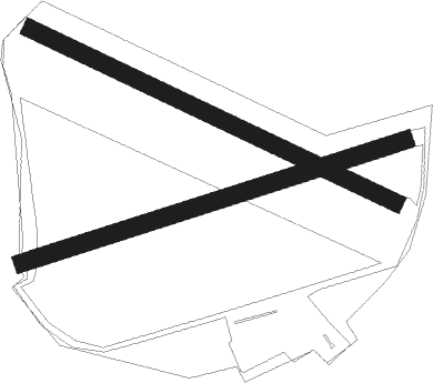
Runway 07 / 25  
 length869m (2851ft)
 bearing82° / 262°
 width38m (125ft)
 surfacegrass
 displ threshold154m (505ft) / 0m (0ft)
Runway 12 / 30  
 length874m (2867ft)
 bearing110° / 290°
 width38m (125ft)
 surfacegrass
 blast zone20m (66ft) / 0m (0ft)

Airport layout


Parking locations

Nearby beacons

codeidentifierdistbearingfrequency
KLFKLASDORF VOR/DME25.5311°115.15
FSDRESDEN NDB28.9193°374
HOZHOLZDORF TACAN28.9277°117.25
HOZHOLZDORF NDB32.6277°406
DNDDME33.3201°115.40
DRNDRESDEN VOR/DME41.6209°114.35
BBIBERLIN BRANDENBURG VOR/DME44.4323°114.10
FWEFUERSTENWALDE VOR/DME44.913°113.30
SDDDME45.5327°114.40
HDOHERMSDORF VOR/DME47.1151°108.65

Disclaimer

The information on this website is not for real aviation. Use this data with the X-Plane flight simulator only! Data taken with kind consent from X-Plane 12 source code and data files. Content is subject to change without notice.