Airports for X-Plane offers a convenient way to explore airports and their related communication information for the X-Plane flight simulator. It only uses data from the X-Plane flight simulator itself, and is therefore more reliable than the data that comes from real aviation websites. You can search for airports by using the ICAO code, or browse for airports per country and state. The information displayed is categorized by airport details, runway information, airport communication, approach frequencies (ILS and Glidepath details), details of nearby beacons, SIDs, STARs and approach procedures.

heliport arriving embassy propeller plane aerodrome port airport authority transit flown non-towered airport runway lighting tarmac landing concrete road passengers airplane gravel seaplane downtown

Cottbus - Cottbus - Drewitz

Airport details

CountryGermany
StateBrandenburg
RegionED
AirspaceBremen Ctr
MunicipalityJänschwalde
Elevation274ft (84m)
TimezoneGMT +1
Coordinates51.88312, 14.52954
Magnetic var
Typeland
Available sinceX-Plane v10.40
ICAO codeEDCD
IATA codeCBU
FAA coden/a

Communication

Cottbus - Drewitz Drewitz Info118.125
Nearby Points of Interest:
Pfarrhaus Atterwasch
-
Protestant Church Atterwasch
-
Stadtpfarrkirche (Peitz)
-
Holy Family church in Sękowice
-
Willmersdorfer Kirche
-
Dorfkirche Sacro
-
Dorfkirche Drachhausen
-
Ludwig-A.-Meyer-Haus
-
Amtsgericht Guben
-
Dorfkirche
-
Village church Leeskow
-
Spreewehrmühle
-
Dorfkirche Sielow (Cottbus)
-
Augusta-Schule
-
Dreifertstraße 8
-
Puschkinpromenade (Cottbus)
-
Amtsgericht Cottbus
-
Katholisch-Apostolische Kirche
-
Wilhelmsmühle
-
Gertraudtenstraße 1 (Cottbus)
-
Village church Klein Muckrow
-
Neues Rathaus
-
Spremberger Straße
-
Schlosskirche Cottbus
-
Stadthaus

Runway info

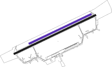
Runway 07 / 25  
 length2489m (8166ft)
 bearing77° / 257°
 width49m (161ft)
 surfaceconcrete
Runway 07L / 25R
 length1883m (6178ft)
 bearing77° / 257°
 width48m (157ft)
 surfacegrass

Airport layout - runway 07L / 25R


Taxiway locations
Parking locations

Nearby beacons

codeidentifierdistbearingfrequency
FWEFUERSTENWALDE VOR/DME34.9323°113.30
KLFKLASDORF VOR/DME36.6278°115.15
FSDRESDEN NDB48.6225°374
DNDDME53.6226°115.40
HDOHERMSDORF VOR/DME57.6190°108.65
OKXFRYDLANT VOR/DME61.8153°114.85
DRNDRESDEN VOR/DME62.6227°114.35

Disclaimer

The information on this website is not for real aviation. Use this data with the X-Plane flight simulator only! Data taken with kind consent from X-Plane 12 source code and data files. Content is subject to change without notice.