Airports for X-Plane offers a convenient way to explore airports and their related communication information for the X-Plane flight simulator. It only uses data from the X-Plane flight simulator itself, and is therefore more reliable than the data that comes from real aviation websites. You can search for airports by using the ICAO code, or browse for airports per country and state. The information displayed is categorized by airport details, runway information, airport communication, approach frequencies (ILS and Glidepath details), details of nearby beacons, SIDs, STARs and approach procedures.

terminal port outskirts hotel local government station traffic airport check-in regional runway lighting government airport terminal bus nearby embassy southwest drome train station airbase jetliner

Spreenhagen - Friedersdorf

Airport details

CountryGermany
StateBrandenburg
Region
AirspaceBremen Ctr
MunicipalityFriedersdorf
Elevation113ft (34m)
TimezoneGMT +1
Coordinates52.28482, 13.79502
Magnetic var
Typeland
Available sinceX-Plane v10.40
ICAO codeEDCF
IATA coden/a
FAA coden/a

Communication

Friedersdorf Friedersdorf Info122.850
Nearby Points of Interest:
Dorfkirche Friedersdorf (Heidesee)
-
Dorfkirche Kablow
-
Heimatmuseum Prieros
-
Village church Gräbendorf
-
Sporthaus Ziegenhals
-
Amtsgericht Königs Wusterhausen
-
Village church Bestensee
-
Funkerberg
-
Dorfkirche Deutsch Wusterhausen
-
Oberförsterei Hammer
-
Protestant Church
-
Herrenhaus Münchehofe
-
Kreuzkirche Schulzendorf
-
Dorfkirche Schulzendorf
-
Wasserwerk Köpenick
-
Friedhof Rahnsdorf
-
Jewish cemetery, Märkisch Buchholz
-
Lido Müggelsee
-
Dorfkirche Töpchin
-
Rathaus
-
Reichsautobahn-Tankstelle Fürstenwalde
-
Gesellschaftshaus Grünau
-
Riviera Grünau
-
Village church Neu Golm
-
Kaiserbahnhof Halbe

Runway info

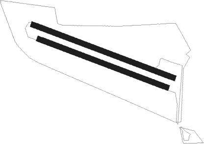
Runway 12 / 30  
 length1101m (3612ft)
 bearing106° / 286°
 width40m (131ft)
 surfacegrass
Runway 12R / 30L  
 length1001m (3284ft)
 bearing106° / 286°
 width40m (131ft)
 surfacegrass

Airport layout


Nearby beacons

codeidentifierdistbearingfrequency
SDDDME11.9287°114.40
BBIBERLIN BRANDENBURG VOR/DME12.9280°114.10
FWEFUERSTENWALDE VOR/DME14.469°113.30
KLFKLASDORF VOR/DME18221°115.15
HOZHOLZDORF TACAN38.1229°117.25
HOZHOLZDORF NDB40.2234°406
LWBLOEWENBERG VOR/DME44.6313°114.55

Disclaimer

The information on this website is not for real aviation. Use this data with the X-Plane flight simulator only! Data taken with kind consent from X-Plane 12 source code and data files. Content is subject to change without notice.