Köthen
Airport details
| Country | Germany |
| State | Saxony-Anhalt |
| Region | ED |
| Airspace | Munich Ctr |
| Municipality | Köthen (Anhalt) |
| Elevation | 300ft (91m) |
| Timezone | GMT +1 |
| Coordinates | 51.72250, 11.94717 |
| Magnetic var | |
| Type | land |
| Available since | X-Plane v10.40 |
| ICAO code | EDCK |
| IATA code | KOQ |
| FAA code | n/a |
Communication
| Köthen Köthen Info | 123.650 |
Nearby Points of Interest:
Köthen Airport
-Rathaus Köthen
-Angelika-Hartmann-Denkmal
-Kriegerdenkmal Wieskau
-Pißdorf Church
-Dorfkirche Gnetsch
-Rathaus Löbejün
-Church of Scheuder
-Schützenhaus Löbejün
-Protestant Church (Werderthau)
-Wilhelm-Pieck-Platz 7
-Kriegerdenkmal Werderthau
-Rittergut Cösitz
-Hallesche Straße 5
-Kaltenmarker Anger 16
-Kriegerdenkmal Krosigk
-Wegweiser Libbesdorf
-Taubenturm Krosigk
-Kloster Petersberg
-Kriegerdenkmal Hinsdorf
-Herrenhaus Mößlitz
-Distanzstein
-Aken railway station
-Protestant Church Zörbig
-Church Wallwitz
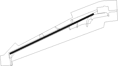
Runway info
| Runway 07 / 25 | ||
| length | 801m (2628ft) | |
| bearing | 77° / 257° | |
| width | 14m (44ft) | |
| surface | concrete | |
| displ threshold | 10m (33ft) / 52m (171ft) | |
Nearby beacons
| code | identifier | dist | bearing | frequency |
|---|---|---|---|---|
| MAG | MAGDEBURG VOR/DME | 17.3 | 331° | 110.45 |
| LND | NORTH(LEIPZIG- DME | 20.1 | 136° | 113.50 |
| CB | COCHSTEDT NDB | 20.2 | 286° | 344 |
| LLD | SOUTH(LEIPZIG- DME | 21.2 | 137° | 112.15 |
| ZIG | LEIPZIG NDB | 21.3 | 131° | 340 |
| SKZ | SCHKEUDITZ (LEIPZIG-HALLE) NDB | 22 | 134° | 357 |
| LEG | LEIPZIG VOR/DME | 26.1 | 119° | 115.85 |
| GOT | GOTEM VOR/DME | 26.2 | 223° | 115.25 |
| ABU | ALTENBURG NDB | 48.7 | 142° | 330 |
| AGD | DME | 49.2 | 143° | 115.30 |
| ERF | ERFURT VOR/DME | 53.4 | 223° | 113.85 |
| EFD | DME | 57.8 | 233° | 112.05 |
Disclaimer
The information on this website is not for real aviation. Use this data with the X-Plane flight simulator only! Data taken with kind consent from X-Plane 12 source code and data files. Content is subject to change without notice.