Güstrow
Airport details
| Country | Germany |
| State | Mecklenburg-Vorpommern |
| Region | ED |
| Airspace | Bremen Ctr |
| Municipality | Güstrow |
| Elevation | 44ft (13m) |
| Timezone | GMT +1 |
| Coordinates | 53.80695, 12.23194 |
| Magnetic var | |
| Type | land |
| Available since | X-Plane v10.40 |
| ICAO code | EDCU |
| IATA code | n/a |
| FAA code | n/a |
Communication
| Güstrow Güstrow Info | 122.000 |
Nearby Points of Interest:
Gleviner Straße 10
-Postamt Güstrow
-Category:Haus der Kirche (Güstrow)
-Church in Recknitz
-Dorfkirche Parum
-Dorfkirche Badendiek
-Church in Bellin
-Gut Bellin
-Gut Diekhof
-Villa Korff
-Church in Warnkenhagen
-Gutshaus Dolgen
-Herrenhaus Schwiessel
-Town hall in Bützow
-Church in Boitin
-Krummes Haus (Bützow)
-Church in Serrahn
-Jüdischer Friedhof (Schwaan)
-Church in Alt Sammit
-Justizvollzugsanstalt Bützow
-Burgwall Wardow
-Herrenhaus Tellow
-Flächennaturdenkmal Wacholderbestand Abt. 4184 Forstrevier Jellen
-Schloss Prebberede
-Church in Woserin
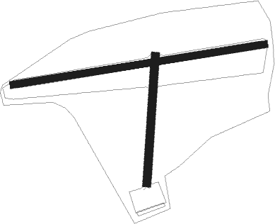
Runway info
Runway 18 / 36  | ||
| length | 532m (1745ft) | |
| bearing | 14° / 194° | |
| width | 35m (115ft) | |
| surface | grass | |
| displ threshold | 34m (112ft) / 0m (0ft) | |
| Runway 09 / 27 | ||
| length | 1074m (3524ft) | |
| bearing | 87° / 267° | |
| width | 30m (98ft) | |
| surface | grass | |
| displ threshold | 208m (682ft) / 0m (0ft) | |
Nearby beacons
| code | identifier | dist | bearing | frequency |
|---|---|---|---|---|
| LAG | LAAGE TACAN | 7 | 26° | 108.25 |
| PI | SCHWERIN-PARCHIM NDB | 23.7 | 223° | 333 |
| PMD | DME | 27.9 | 229° | 117.50 |
| PAH | SCHWERIN-PARCHIM NDB | 31.9 | 234° | 315 |
| BKD | BRUENKENDORF VOR/DME | 52.4 | 222° | 117.70 |
| LWB | LOEWENBERG VOR/DME | 62.8 | 135° | 114.55 |
Disclaimer
The information on this website is not for real aviation. Use this data with the X-Plane flight simulator only! Data taken with kind consent from X-Plane 12 source code and data files. Content is subject to change without notice.