Rostock - Purkshof
Airport details
| Country | Germany |
| State | Mecklenburg-Vorpommern |
| Region | ED |
| Airspace | Bremen Ctr |
| Municipality | Rövershagen |
| Elevation | 64ft (20m) |
| Timezone | GMT +1 |
| Coordinates | 54.16083, 12.24861 |
| Magnetic var | |
| Type | land |
| Available since | X-Plane v10.40 |
| ICAO code | EDCX |
| IATA code | n/a |
| FAA code | n/a |
Communication
| Purkshof Purkshof | 122.400 |
Nearby Points of Interest:
Gutshaus Klein Kussewitz
-Graal-Müritz station
-Katharinenkloster
-Kerkhoffhaus
-Rostock town hall
-Teepott Warnemünde
-Kröpeliner Straße
-Church in Gresenhorst
-Kurhaus Warnemünde
-Zeecksche Villa
-Haus der Freundschaft
-Rathaus Ribnitz-Damgarten
-Dorfkirche Kuhlrade
-Dierhagen church
-Burgwall Tessin
-Church in Buchholz
-Rathaus Marlow
-Kapelle Althof
-Beinhaus
-Doberan Abbey
-Amtshaus
-Möckelhaus
-Gutshaus Dolgen
-Burgwall Reddershof
-Großes Palais
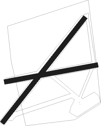
Runway info
Runway 08 / 26  | ||
| length | 763m (2503ft) | |
| bearing | 87° / 267° | |
| width | 40m (131ft) | |
| surface | grass | |
| displ threshold | 81m (266ft) / 85m (279ft) | |
| Runway 04 / 22 | ||
| length | 1096m (3596ft) | |
| bearing | 58° / 238° | |
| width | 40m (131ft) | |
| surface | grass | |
| displ threshold | 369m (1211ft) / 0m (0ft) | |
Nearby beacons
| code | identifier | dist | bearing | frequency |
|---|---|---|---|---|
| LAG | LAAGE TACAN | 14.5 | 171° | 108.25 |
| PI | SCHWERIN-PARCHIM NDB | 43.7 | 206° | 333 |
| PMD | DME | 47.1 | 212° | 117.50 |
| PAH | SCHWERIN-PARCHIM NDB | 50.4 | 217° | 315 |
| CDA | CODAN VOR/DME | 50.6 | 9° | 114.90 |
Disclaimer
The information on this website is not for real aviation. Use this data with the X-Plane flight simulator only! Data taken with kind consent from X-Plane 12 source code and data files. Content is subject to change without notice.