Hamburg - Hamburg Fuhlsbuettel
Airport details
| Country | Germany |
| State | Hamburg |
| Region | ED |
| Airspace | Bremen Ctr |
| Elevation | 53ft (16m) |
| Timezone | GMT +1 |
| Coordinates | 53.62414, 9.99699 |
| Magnetic var | |
| Type | land |
| Available since | X-Plane v10.40 |
| ICAO code | EDDH |
| IATA code | HAM |
| FAA code | n/a |
Communication
| Hamburg Fuhlsbuettel Hamburg ATIS | 124.325 |
| Hamburg Fuhlsbuettel Hamburg Ground | 121.805 |
| Hamburg Fuhlsbuettel Hamburg Tower | 126.855 |
| Hamburg Fuhlsbuettel Hamburg Director | 118.205 |
| Hamburg Fuhlsbuettel Bremen Radar | 136.675 |
| Hamburg Fuhlsbuettel Bremen Radar | 134.255 |
Approach frequencies
| LOC | RW33 | 109.9 | 18.00mi |
| ILS-cat-III | RW23 | 111.5 | 18.00mi |
| ILS-cat-I | RW05 | 110.5 | 18.00mi |
| ILS-cat-I | RW15 | 109.55 | 18.00mi |
| 3° GS | RW05 | 110.5 | 18.00mi |
| 3° GS | RW15 | 109.55 | 18.00mi |
| 3° GS | RW23 | 111.5 | 18.00mi |
Nearby Points of Interest:
JVA Fuhlsbüttel
-Superior postal administration
-Überseering 12
-New-York-Ring 6 und 6a
-Wasserturm Hamburg-Winterhude
-Barmbek water tower
-Haus Stübekamp 75
-Haus Kornweg 17E
-Frank’sche Siedlung
-Adolf von Elm Hof
-Isestraße 95
-Eppendorfer Brücke
-Jarrestadt
-Falkenried-Terrassen
-Schleidenhof
-Sophienterrasse
-Margarine Voss
-Herbert-Weichmann-Brücke
-Villa Süchting
-Bundeswehrkrankenhaus Hamburg
-Ebenezer-Krankenhaus
-Literaturhaus Hamburg
-Schröderstift, Hamburg
-Fontenay-Denkmal
-Curiohaus
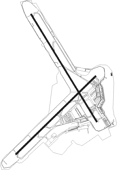
Runway info
Runway 05 / 23  | ||
| length | 3245m (10646ft) | |
| bearing | 64° / 244° | |
| width | 46m (151ft) | |
| surface | asphalt | |
| displ threshold | 298m (978ft) / 155m (509ft) | |
| blast zone | 59m (194ft) / 73m (240ft) | |
| Runway 15 / 33 | ||
| length | 3661m (12011ft) | |
| bearing | 139° / 319° | |
| width | 46m (151ft) | |
| surface | asphalt | |
| displ threshold | 0m (0ft) / 446m (1463ft) | |
| blast zone | 59m (194ft) / 50m (164ft) | |
Airport layout
Taxiway locations
Parking locations
|
Nearby beacons
| code | identifier | dist | bearing | frequency |
|---|---|---|---|---|
| ALF | DME | 0.6 | 346° | 115.80 |
| HAM | HAMBURG VORTAC | 8.2 | 74° | 113.10 |
| LYE | LUEBECK NDB | 27 | 76° | 394 |
| FSB | FASSBERG NDB | 43.1 | 165° | 284 |
| HN | HOHN NDB | 43.7 | 335° | 344 |
| HNT | HOHN TACAN | 44.3 | 326° | 115.30 |
| KIL | KIEL-HOLTENAU NDB | 45.4 | 9° | 353 |
| KHD | (HOLTENAU) DME-ILS | 45.6 | 11° | 109.50 |
| SWG | SCHLESWIG TACAN | 53.1 | 330° | 111.80 |
| NIE | NIENBURG VOR | 64 | 212° | 116.50 |
Departure and arrival routes
| Transition altitude | 5000ft |
| SID end points | distance | outbound heading | |
|---|---|---|---|
| RW05 | |||
| LUGE1C | 30mi | 65° | |
| RAMA4C | 34mi | 85° | |
| AMLU9C | 17mi | 121° | |
| IDEK6C | 43mi | 221° | |
| BASU2C | 67mi | 235° | |
| ELSO1C | 15mi | 274° | |
| EKER9C | 53mi | 351° | |
| RW15 | |||
| LUGE1D | 30mi | 65° | |
| RAMA4D | 34mi | 85° | |
| AMLU9D | 17mi | 121° | |
| IDEK7D | 43mi | 221° | |
| BASU5D | 67mi | 235° | |
| ELSO1D | 15mi | 274° | |
| EKER1D | 53mi | 351° | |
| RW23 | |||
| LUGE1B | 30mi | 65° | |
| RAMA4B | 34mi | 85° | |
| AMLU1B | 17mi | 121° | |
| IDEK6B | 43mi | 221° | |
| BASU4B | 67mi | 235° | |
| ELSO1B | 15mi | 274° | |
| EKER9B | 53mi | 351° | |
| RW33 | |||
| LUGE1G | 30mi | 65° | |
| RAMA4G | 34mi | 85° | |
| AMLU9G | 17mi | 121° | |
| IDEK5G | 43mi | 221° | |
| BASU2G | 67mi | 235° | |
| ELSO1G | 15mi | 274° | |
| EKER9G | 53mi | 351° | |
| STAR starting points | distance | inbound heading | |
|---|---|---|---|
| RW05 | |||
| RIBS5A | 25.9 | 106° | |
| BOGM1N, BOGM3A | 23.7 | 219° | |
| RARU4A | 24.2 | 269° | |
| NOLG4A | 14.5 | 328° | |
| RW15 | |||
| RIBS1D | 25.9 | 106° | |
| BOGM1D | 23.7 | 219° | |
| RARU1D | 24.2 | 269° | |
| NOLG1D, NOLG1W | 14.5 | 328° | |
| RW23 | |||
| RIBS1P | 25.9 | 106° | |
| BOGM1P | 23.7 | 219° | |
| RARU1P | 24.2 | 269° | |
| NOLG1P | 14.5 | 328° | |
| RW33 | |||
| RIBS1S | 25.9 | 106° | |
| BOGM1S | 23.7 | 219° | |
| RARU1S | 24.2 | 269° | |
| NOLG1S | 14.5 | 328° | |
Instrument approach procedures
| runway | airway (heading) | route (dist, bearing) |
|---|---|---|
| RW05 | DH257 (65°) | DH257 3000ft DH258 (4mi, 63°) 3000ft |
| RW05 | HAM (254°) | HAM 4000ft DH227 (3mi, 181°) DH233 (24mi, 244°) 4000ft DH257 (5mi, 306°) 3000ft DH258 (4mi, 63°) 3000ft |
| RNAV | DH258 3000ft ANEXI (4mi, 63°) 3000ft EDDH (10mi, 66°) 82ft DH031 (6mi, 60°) DH032 (7mi, 93°) HAM (4mi, 273°) 4000ft | |
| RW15 | DH457 (139°) | DH457 3000ft DH458 (4mi, 139°) 3000ft |
| RW15 | HAM (254°) | HAM 4000ft DH407 (4mi, 281°) DH413 (16mi, 319°) 4000ft DH457 (5mi, 253°) 3000ft DH458 (4mi, 139°) 3000ft |
| RNAV | DH458 3000ft DEVOD (4mi, 139°) 3000ft EDDH (11mi, 140°) 103ft DH050 (2mi, 135°) HAM (8mi, 61°) 4000ft | |
| RW23 | DH657 (242°) | DH657 3000ft DH658 (4mi, 244°) 3000ft |
| RW23 | HAM (254°) | HAM 4000ft DH612 (6mi, 81°) DH613 (4mi, 64°) 4000ft DH657 (5mi, 305°) 3000ft DH658 (4mi, 244°) 3000ft |
| RNAV | DH658 3000ft PISAS (4mi, 244°) 3000ft EDDH (10mi, 241°) 93ft DH111 (5mi, 248°) HAM (13mi, 72°) 4000ft | |
| RW33 | DH857 (319°) | DH857 3000ft DH858 (4mi, 320°) 3000ft |
| RW33 | HAM (254°) | HAM 4000ft DH830 (9mi, 168°) DH832 (8mi, 140°) 4000ft DH857 (5mi, 253°) 3000ft DH858 (4mi, 320°) 3000ft |
| RNAV | DH858 3000ft SOSAX (4mi, 319°) 3000ft EDDH (9mi, 318°) 85ft DH089 (6mi, 321°) HAM (10mi, 96°) 4000ft |
Holding patterns
| STAR name | hold at | type | turn | heading* | altitude | leg | speed limit |
|---|---|---|---|---|---|---|---|
| BOGM1D | BOGMU | VHF | right | 49 (229)° | 4000ft - 11000ft | 1.0min timed | 230 |
| BOGM1N | BOGMU | VHF | right | 49 (229)° | 4000ft - 11000ft | 1.0min timed | 230 |
| BOGM1P | BOGMU | VHF | right | 49 (229)° | 4000ft - 11000ft | 1.0min timed | 230 |
| BOGM1S | BOGMU | VHF | right | 49 (229)° | 4000ft - 11000ft | 1.0min timed | 230 |
| BOGM3A | BOGMU | VHF | right | 49 (229)° | 4000ft - 11000ft | 1.0min timed | 230 |
| NOLG1D | NOLGO | VHF | left | 185 (5)° | 4000ft - 11000ft | 1.0min timed | 230 |
| NOLG1P | NOLGO | VHF | left | 185 (5)° | 4000ft - 11000ft | 1.0min timed | 230 |
| NOLG1S | NOLGO | VHF | left | 185 (5)° | 4000ft - 11000ft | 1.0min timed | 230 |
| NOLG1W | NOLGO | VHF | left | 185 (5)° | 4000ft - 11000ft | 1.0min timed | 230 |
| NOLG4A | NOLGO | VHF | left | 185 (5)° | 4000ft - 11000ft | 1.0min timed | 230 |
| RARU1D | RARUP | VHF | right | 96 (276)° | 4000ft - 11000ft | 1.0min timed | 230 |
| RARU1P | RARUP | VHF | right | 96 (276)° | 4000ft - 11000ft | 1.0min timed | 230 |
| RARU1S | RARUP | VHF | right | 96 (276)° | 4000ft - 11000ft | 1.0min timed | 230 |
| RARU4A | RARUP | VHF | right | 96 (276)° | 4000ft - 11000ft | 1.0min timed | 230 |
| RIBS1D | RIBSO | VHF | right | 208 (28)° | 4000ft - 11000ft | 1.0min timed | 230 |
| RIBS1P | RIBSO | VHF | right | 208 (28)° | 4000ft - 11000ft | 1.0min timed | 230 |
| RIBS1S | RIBSO | VHF | right | 208 (28)° | 4000ft - 11000ft | 1.0min timed | 230 |
| RIBS5A | RIBSO | VHF | right | 208 (28)° | 4000ft - 11000ft | 1.0min timed | 230 |
| *) magnetic outbound (inbound) holding course | |||||||
Disclaimer
The information on this website is not for real aviation. Use this data with the X-Plane flight simulator only! Data taken with kind consent from X-Plane 12 source code and data files. Content is subject to change without notice.