Airports for X-Plane offers a convenient way to explore airports and their related communication information for the X-Plane flight simulator. It only uses data from the X-Plane flight simulator itself, and is therefore more reliable than the data that comes from real aviation websites. You can search for airports by using the ICAO code, or browse for airports per country and state. The information displayed is categorized by airport details, runway information, airport communication, approach frequencies (ILS and Glidepath details), details of nearby beacons, SIDs, STARs and approach procedures.

traffic frankfurt airport ferry hangar airspeed airline faa consulate stolport airport heliport aircraft carrier automated airport weather station public transport capital near runway lighting airports commuter control tower

Gotha - Gotha-ost

Airport details

CountryGermany
StateThuringia
RegionED
AirspaceMunich Ctr
MunicipalityGotha
Elevation990ft (302m)
TimezoneGMT +1
Coordinates50.97055, 10.72806
Magnetic var
Typeland
Available sinceX-Plane v10.40
ICAO codeEDEG
IATA coden/a
FAA coden/a

Communication

Gotha-Ost Gotha Info122.500
Nearby Points of Interest:
Volkshaus zum Mohren, Gotha
-
Villa Madelung
-
Winterpalais (Gotha)
-
Siebleber Straße 24
-
Zwei-Welten-Säule
-
Brühl 9-11
-
Brühl 13-15
-
Petermann-Denkmal
-
Teeschlösschen Gotha
-
Kavaliershaus (Gotha)
-
Prinzenpalais
-
Reyherschule
-
Gotha Observatory
-
Schloss Mönchhof Siebleben
-
Jewish Cemetery
-
Tivoli (Gotha)
-
Sankt-Petri-Kirche
-
Leinakanal
-
Sankt-Viti-Kirche Wechmar
-
St. Vitus (Eckardtsleben)
-
St. Trinitatis (Illeben)
-
Rathaus
-
Saint Wigbert Church (Sülzenbrücken)
-
St. Laurentius (Gebesee)
-
Alte Gerberei

Runway info

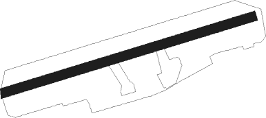
Runway 08 / 26
 length811m (2661ft)
 bearing82° / 262°
 width30m (98ft)
 surfacegrass
 displ threshold256m (840ft) / 200m (656ft)

Airport layout


Nearby beacons

codeidentifierdistbearingfrequency
EFDDME8.787°112.05
ERFERFURT VOR/DME19.292°113.85
GOTGOTEM VOR/DME39.667°115.25
CBCOCHSTEDT NDB59.939°344
BAYBAYREUTH VOR68.6137°110.60

Disclaimer

The information on this website is not for real aviation. Use this data with the X-Plane flight simulator only! Data taken with kind consent from X-Plane 12 source code and data files. Content is subject to change without notice.