Hammelburg - Lager Hammelburg
Airport details
| Country | Germany |
| State | Bavaria |
| Region | ED |
| Airspace | Langen Ctr |
| Municipality | Hammelburg |
| Elevation | 1130ft (344m) |
| Timezone | GMT +1 |
| Coordinates | 50.09861, 9.88333 |
| Magnetic var | |
| Type | land |
| Available since | X-Plane v10.40 |
| ICAO code | EDFJ |
| IATA code | n/a |
| FAA code | n/a |
Communication
| Lager Hammelburg Hammelburg Info | 118.425 |
Nearby Points of Interest:
Pfarrhaus
-Rathaus
-Amtsgericht
-Mönchsturm (Hammelburg)
-Pfarrhof
-Pfarrkirche
-Filialkirche
-Bürgerzentrum
-Kapelle
-Evangelische Kirche (Waizenbach)
-Tretstein waterfall
-Schule
-Torturm
-Kreuzweg
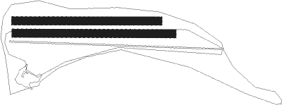
Runway info
Runway 09L / 27R  | ||
| length | 500m (1640ft) | |
| bearing | 93° / 273° | |
| width | 28m (92ft) | |
| surface | grass | |
| Runway 10 / 28 | ||
| length | 549m (1801ft) | |
| bearing | 93° / 273° | |
| width | 10m (33ft) | |
| surface | asphalt | |
| Runway 09R / 27L | ||
| length | 549m (1801ft) | |
| bearing | 93° / 273° | |
| width | 30m (98ft) | |
| surface | grass | |
Nearby beacons
| code | identifier | dist | bearing | frequency |
|---|---|---|---|---|
| GED | GEDERN VORTAC | 30.7 | 296° | 110.80 |
| FUL | FULDA VOR/DME | 31.9 | 328° | 112.10 |
| CHA | CHARLIE VOR/DME | 34.2 | 258° | 115.35 |
| NSN | NIEDERSTETTEN NDB | 42.3 | 173° | 311 |
| ILM | ILLESHEIM NDB | 42.4 | 141° | 488 |
| NDD | DME-ILS | 42.4 | 174° | 108.70 |
| ANS | ANSBACH NDB | 55.6 | 137° | 452 |
| DKB | DINKELSBUEHL VORTAC | 59 | 160° | 117.80 |
| SHD | HALL DME | 59.1 | 186° | 108.05 |
| FTZ | FRITZLAR NDB | 61.8 | 335° | 468 |
Disclaimer
The information on this website is not for real aviation. Use this data with the X-Plane flight simulator only! Data taken with kind consent from X-Plane 12 source code and data files. Content is subject to change without notice.